You are here: Home > Network List > C8 - Canadian Seismic Research Network () Stations List
> Station GRIB Gribbell Island, BC, CA > Earthquake Result Viewer
GRIB Gribbell Island, BC, CA - Earthquake Result Viewer
| Earthquake location: |
Kyrgyzstan-Xinjiang Border Reg. |
| Earthquake latitude/longitude: |
41.3/78.6 |
| Earthquake time(UTC): |
2024/01/22 (022) 18:09:04 GMT |
| Earthquake Depth: |
13 km |
| Earthquake Magnitude: |
7.0 Mww |
| Earthquake Catalog/Contributor: |
NEIC PDE/us |
|
| Network: |
C8 Canadian Seismic Research Network () |
| Station: |
GRIB Gribbell Island, BC, CA |
| Lat/Lon: |
53.34 N/129.14 W |
| Elevation: |
418 m |
|
| Distance: |
82.8 deg |
| Az: |
16.368 deg |
| Baz: |
339.253 deg |
| Ray Param: |
0.046659946 |
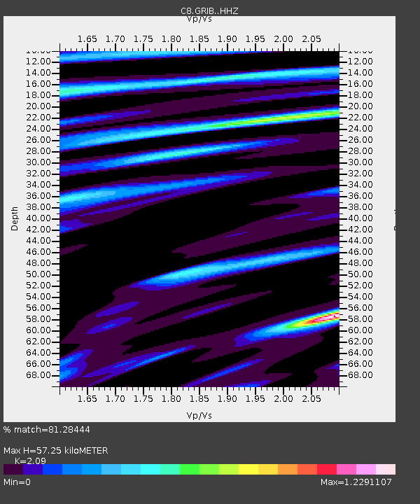
| Estimated Moho Depth: |
57.25 km |
| Estimated Crust Vp/Vs: |
2.09 |
| Assumed Crust Vp: |
6.545 km/s |
| Estimated Crust Vs: |
3.132 km/s |
| Estimated Crust Poisson's Ratio: |
0.35 |
|
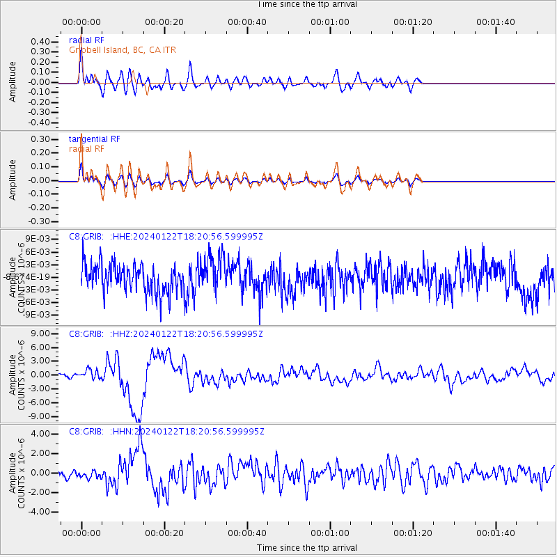
| Radial Match: |
81.28444 % |
| Radial Bump: |
400 |
| Transverse Match: |
81.27292 % |
| Transverse Bump: |
400 |
| SOD ConfigId: |
33437571 |
| Insert Time: |
2024-02-05 18:18:52.284 +0000 |
| GWidth: |
2.5 |
| Max Bumps: |
400 |
| Tol: |
0.001 |
|
Signal To Noise
| Channel | StoN | STA | LTA |
| C8:GRIB: :HHZ:20240122T18:20:56.599995Z | 3.5372913 | 1.0092976E-6 | 2.8533066E-7 |
| C8:GRIB: :HHN:20240122T18:20:56.599995Z | 0.6525624 | 3.5348623E-7 | 5.416896E-7 |
| C8:GRIB: :HHE:20240122T18:20:56.599995Z | 1.3759762 | 4.423792E-9 | 3.2150207E-9 |
| Arrivals |
| Ps | 9.8 SECOND |
| PpPs | 26 SECOND |
| PsPs/PpSs | 36 SECOND |


