You are here: Home > Network List > CN - Canadian National Seismograph Network Stations List
> Station CLRN Clyde River, NU, CA > Earthquake Result Viewer
CLRN Clyde River, NU, CA - Earthquake Result Viewer
| Earthquake location: |
Kyrgyzstan-Xinjiang Border Reg. |
| Earthquake latitude/longitude: |
41.3/78.6 |
| Earthquake time(UTC): |
2024/01/22 (022) 18:09:04 GMT |
| Earthquake Depth: |
13 km |
| Earthquake Magnitude: |
7.0 Mww |
| Earthquake Catalog/Contributor: |
NEIC PDE/us |
|
| Network: |
CN Canadian National Seismograph Network |
| Station: |
CLRN Clyde River, NU, CA |
| Lat/Lon: |
70.47 N/68.59 W |
| Elevation: |
9.0 m |
|
| Distance: |
66.1 deg |
| Az: |
348.517 deg |
| Baz: |
26.508 deg |
| Ray Param: |
0.057858158 |
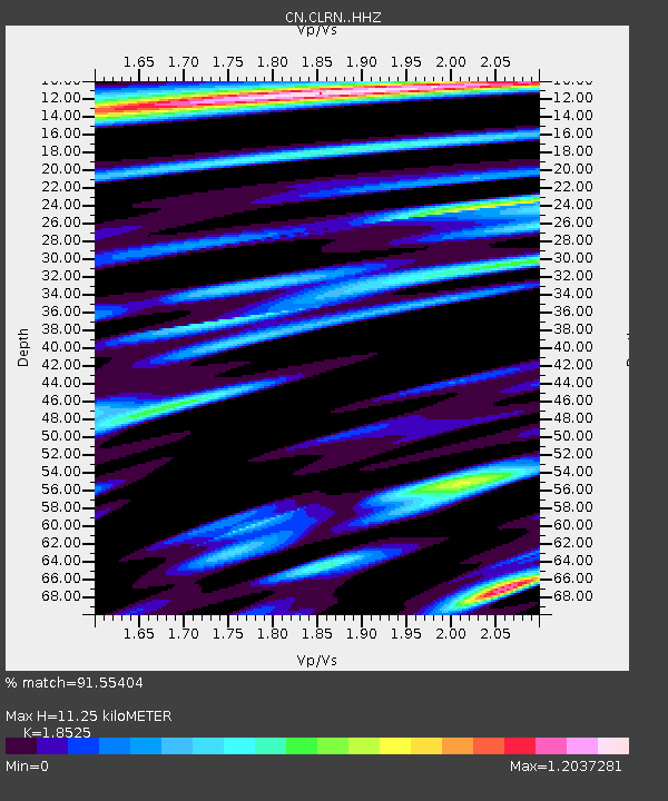
| Estimated Moho Depth: |
11.25 km |
| Estimated Crust Vp/Vs: |
1.85 |
| Assumed Crust Vp: |
6.307 km/s |
| Estimated Crust Vs: |
3.404 km/s |
| Estimated Crust Poisson's Ratio: |
0.29 |
|
| Radial Match: |
91.55404 % |
| Radial Bump: |
400 |
| Transverse Match: |
76.62886 % |
| Transverse Bump: |
400 |
| SOD ConfigId: |
33437571 |
| Insert Time: |
2024-02-05 18:21:11.441 +0000 |
| GWidth: |
2.5 |
| Max Bumps: |
400 |
| Tol: |
0.001 |
|

Signal To Noise
| Channel | StoN | STA | LTA |
| CN:CLRN: :HHZ:20240122T18:19:19.760029Z | 15.172069 | 1.6131189E-6 | 1.06321615E-7 |
| CN:CLRN: :HHN:20240122T18:19:19.760029Z | 3.960689 | 7.379414E-7 | 1.8631641E-7 |
| CN:CLRN: :HHE:20240122T18:19:19.760029Z | 1.6295459 | 6.2171785E-7 | 3.8152828E-7 |
| Arrivals |
| Ps | 1.6 SECOND |
| PpPs | 4.9 SECOND |
| PsPs/PpSs | 6.5 SECOND |


