You are here: Home > Network List > CN - Canadian National Seismograph Network Stations List
> Station TBO Thunder Bay, ON, CA > Earthquake Result Viewer
TBO Thunder Bay, ON, CA - Earthquake Result Viewer
| Earthquake location: |
Kyrgyzstan-Xinjiang Border Reg. |
| Earthquake latitude/longitude: |
41.3/78.6 |
| Earthquake time(UTC): |
2024/01/22 (022) 18:09:04 GMT |
| Earthquake Depth: |
13 km |
| Earthquake Magnitude: |
7.0 Mww |
| Earthquake Catalog/Contributor: |
NEIC PDE/us |
|
| Network: |
CN Canadian National Seismograph Network |
| Station: |
TBO Thunder Bay, ON, CA |
| Lat/Lon: |
48.65 N/89.41 W |
| Elevation: |
475 m |
|
| Distance: |
89.8 deg |
| Az: |
352.112 deg |
| Baz: |
8.974 deg |
| Ray Param: |
0.041730296 |
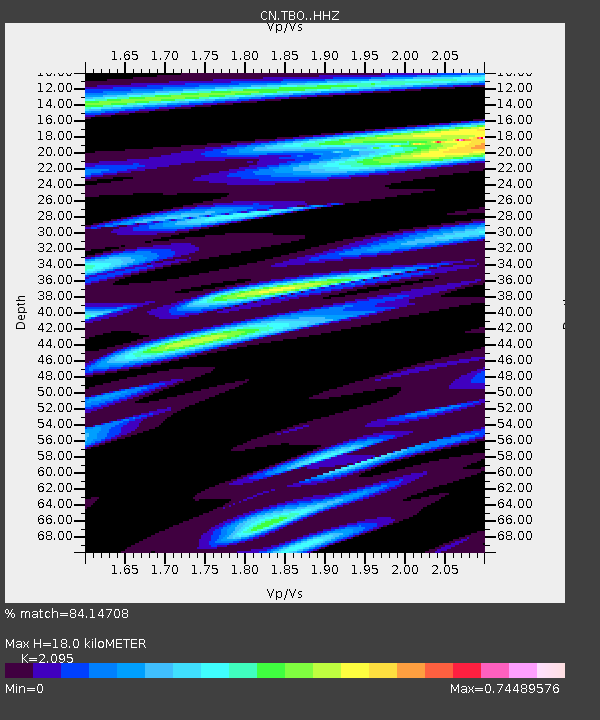
| Estimated Moho Depth: |
18.0 km |
| Estimated Crust Vp/Vs: |
2.10 |
| Assumed Crust Vp: |
6.467 km/s |
| Estimated Crust Vs: |
3.087 km/s |
| Estimated Crust Poisson's Ratio: |
0.35 |
|
| Radial Match: |
84.14708 % |
| Radial Bump: |
399 |
| Transverse Match: |
75.934456 % |
| Transverse Bump: |
400 |
| SOD ConfigId: |
33437571 |
| Insert Time: |
2024-02-05 18:22:54.011 +0000 |
| GWidth: |
2.5 |
| Max Bumps: |
400 |
| Tol: |
0.001 |
|

Signal To Noise
| Channel | StoN | STA | LTA |
| CN:TBO: :HHZ:20240122T18:21:31.279988Z | 3.2939928 | 9.488105E-7 | 2.8804268E-7 |
| CN:TBO: :HHN:20240122T18:21:31.279988Z | 2.4658144 | 5.960922E-7 | 2.4174253E-7 |
| CN:TBO: :HHE:20240122T18:21:31.279988Z | 0.7282645 | 2.0803142E-7 | 2.8565367E-7 |
| Arrivals |
| Ps | 3.1 SECOND |
| PpPs | 8.5 SECOND |
| PsPs/PpSs | 12 SECOND |


