You are here: Home > Network List > LM - Michigan State University Seismic Network Stations List
> Station NHBP Nengshka Wabeno, Nottawaseppi Huron Band of the Potawatomi > Earthquake Result Viewer
NHBP Nengshka Wabeno, Nottawaseppi Huron Band of the Potawatomi - Earthquake Result Viewer
| Earthquake location: |
Kyrgyzstan-Xinjiang Border Reg. |
| Earthquake latitude/longitude: |
41.3/78.6 |
| Earthquake time(UTC): |
2024/01/22 (022) 18:09:04 GMT |
| Earthquake Depth: |
13 km |
| Earthquake Magnitude: |
7.0 Mww |
| Earthquake Catalog/Contributor: |
NEIC PDE/us |
|
| Network: |
LM Michigan State University Seismic Network |
| Station: |
NHBP Nengshka Wabeno, Nottawaseppi Huron Band of the Potawatomi |
| Lat/Lon: |
42.10 N/85.27 W |
| Elevation: |
226 m |
|
| Distance: |
95.7 deg |
| Az: |
348.039 deg |
| Baz: |
12.117 deg |
| Ray Param: |
0.040707625 |
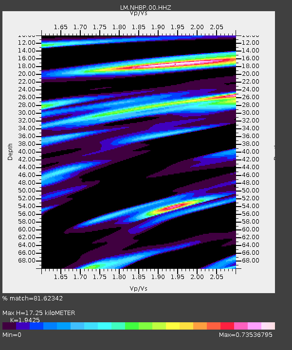
| Estimated Moho Depth: |
17.25 km |
| Estimated Crust Vp/Vs: |
1.94 |
| Assumed Crust Vp: |
6.483 km/s |
| Estimated Crust Vs: |
3.337 km/s |
| Estimated Crust Poisson's Ratio: |
0.32 |
|
| Radial Match: |
81.62342 % |
| Radial Bump: |
400 |
| Transverse Match: |
56.31575 % |
| Transverse Bump: |
400 |
| SOD ConfigId: |
33437571 |
| Insert Time: |
2024-02-05 18:27:00.527 +0000 |
| GWidth: |
2.5 |
| Max Bumps: |
400 |
| Tol: |
0.001 |
|

Signal To Noise
| Channel | StoN | STA | LTA |
| LM:NHBP:00:HHZ:20240122T18:21:58.360005Z | 2.762546 | 7.600838E-7 | 2.7513886E-7 |
| LM:NHBP:00:HHN:20240122T18:21:58.360005Z | 0.9697152 | 3.0384106E-7 | 3.1333022E-7 |
| LM:NHBP:00:HHE:20240122T18:21:58.360005Z | 0.6664707 | 2.1146505E-7 | 3.1729084E-7 |
| Arrivals |
| Ps | 2.6 SECOND |
| PpPs | 7.7 SECOND |
| PsPs/PpSs | 10 SECOND |


