You are here: Home > Network List > MB - Montana Regional Seismic Network Stations List
> Station FCMT Ford Creek > Earthquake Result Viewer
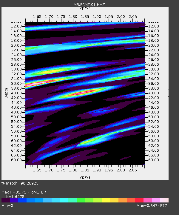
FCMT Ford Creek - Earthquake Result Viewer
| Earthquake location: |
Kyrgyzstan-Xinjiang Border Reg. |
| Earthquake latitude/longitude: |
41.3/78.6 |
| Earthquake time(UTC): |
2024/01/22 (022) 18:09:04 GMT |
| Earthquake Depth: |
13 km |
| Earthquake Magnitude: |
7.0 Mww |
| Earthquake Catalog/Contributor: |
NEIC PDE/us |
|
| Network: |
MB Montana Regional Seismic Network |
| Station: |
FCMT Ford Creek |
| Lat/Lon: |
46.46 N/110.86 W |
| Elevation: |
1836 m |
|
| Distance: |
92.2 deg |
| Az: |
6.561 deg |
| Baz: |
352.843 deg |
| Ray Param: |
0.041490052 |
| Estimated Moho Depth: |
35.75 km |
| Estimated Crust Vp/Vs: |
1.65 |
| Assumed Crust Vp: |
6.306 km/s |
| Estimated Crust Vs: |
3.828 km/s |
| Estimated Crust Poisson's Ratio: |
0.21 |
|
| Radial Match: |
90.26923 % |
| Radial Bump: |
400 |
| Transverse Match: |
82.69696 % |
| Transverse Bump: |
400 |
| SOD ConfigId: |
33437571 |
| Insert Time: |
2024-02-05 18:27:05.252 +0000 |
| GWidth: |
2.5 |
| Max Bumps: |
400 |
| Tol: |
0.001 |
|

Signal To Noise
| Channel | StoN | STA | LTA |
| MB:FCMT:01:HHZ:20240122T18:21:42.349995Z | 5.562041 | 1.0208915E-6 | 1.8354622E-7 |
| MB:FCMT:01:HHN:20240122T18:21:42.349995Z | 1.8682133 | 3.1098836E-7 | 1.6646297E-7 |
| MB:FCMT:01:HHE:20240122T18:21:42.349995Z | 1.1510315 | 2.5508209E-7 | 2.2161173E-7 |
| Arrivals |
| Ps | 3.7 SECOND |
| PpPs | 15 SECOND |
| PsPs/PpSs | 18 SECOND |


