You are here: Home > Network List > MB - Montana Regional Seismic Network Stations List
> Station SRMT Salmond Ranch > Earthquake Result Viewer
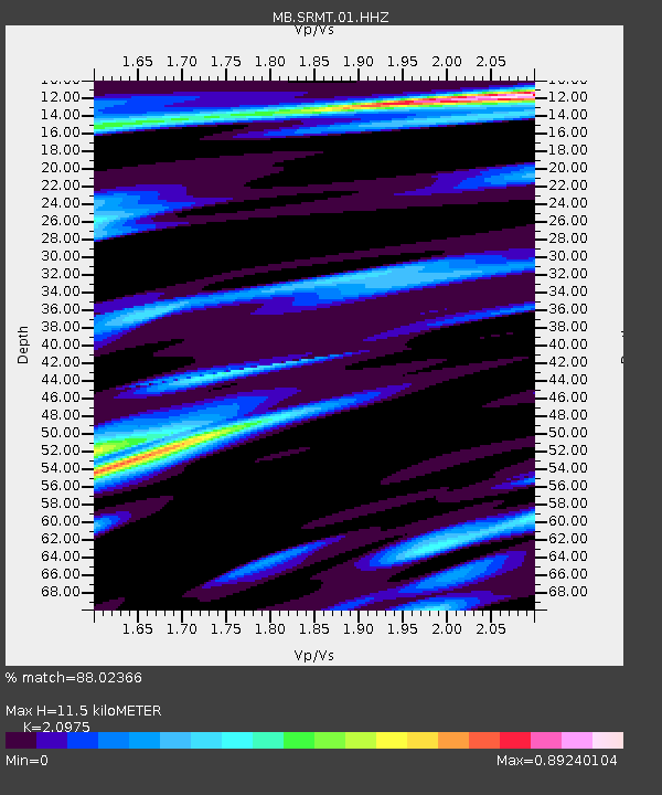
SRMT Salmond Ranch - Earthquake Result Viewer
| Earthquake location: |
Kyrgyzstan-Xinjiang Border Reg. |
| Earthquake latitude/longitude: |
41.3/78.6 |
| Earthquake time(UTC): |
2024/01/22 (022) 18:09:04 GMT |
| Earthquake Depth: |
13 km |
| Earthquake Magnitude: |
7.0 Mww |
| Earthquake Catalog/Contributor: |
NEIC PDE/us |
|
| Network: |
MB Montana Regional Seismic Network |
| Station: |
SRMT Salmond Ranch |
| Lat/Lon: |
47.78 N/112.61 W |
| Elevation: |
1522 m |
|
| Distance: |
90.8 deg |
| Az: |
7.566 deg |
| Baz: |
351.538 deg |
| Ray Param: |
0.04167709 |
| Estimated Moho Depth: |
11.5 km |
| Estimated Crust Vp/Vs: |
2.10 |
| Assumed Crust Vp: |
6.353 km/s |
| Estimated Crust Vs: |
3.029 km/s |
| Estimated Crust Poisson's Ratio: |
0.35 |
|
| Radial Match: |
88.02366 % |
| Radial Bump: |
400 |
| Transverse Match: |
76.57062 % |
| Transverse Bump: |
400 |
| SOD ConfigId: |
33437571 |
| Insert Time: |
2024-02-05 18:27:15.574 +0000 |
| GWidth: |
2.5 |
| Max Bumps: |
400 |
| Tol: |
0.001 |
|

Signal To Noise
| Channel | StoN | STA | LTA |
| MB:SRMT:01:HHZ:20240122T18:21:35.599995Z | 9.257696 | 1.3573956E-6 | 1.4662348E-7 |
| MB:SRMT:01:HHN:20240122T18:21:35.599995Z | 2.0506654 | 3.8607837E-7 | 1.8826981E-7 |
| MB:SRMT:01:HHE:20240122T18:21:35.599995Z | 1.552762 | 2.5476655E-7 | 1.6407314E-7 |
| Arrivals |
| Ps | 2.0 SECOND |
| PpPs | 5.5 SECOND |
| PsPs/PpSs | 7.5 SECOND |


