You are here: Home > Network List > PS - Pacific21 Stations List
> Station JAY Jayapura, Indonesia > Earthquake Result Viewer
JAY Jayapura, Indonesia - Earthquake Result Viewer
| Earthquake location: |
Kyrgyzstan-Xinjiang Border Reg. |
| Earthquake latitude/longitude: |
41.3/78.6 |
| Earthquake time(UTC): |
2024/01/22 (022) 18:09:04 GMT |
| Earthquake Depth: |
13 km |
| Earthquake Magnitude: |
7.0 Mww |
| Earthquake Catalog/Contributor: |
NEIC PDE/us |
|
| Network: |
PS Pacific21 |
| Station: |
JAY Jayapura, Indonesia |
| Lat/Lon: |
2.51 S/140.70 E |
| Elevation: |
439 m |
|
| Distance: |
71.1 deg |
| Az: |
111.097 deg |
| Baz: |
315.255 deg |
| Ray Param: |
0.054554824 |
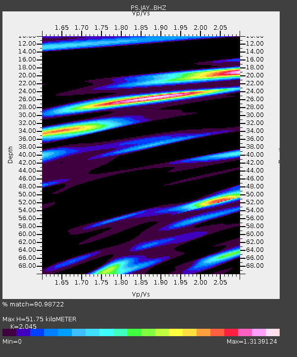
| Estimated Moho Depth: |
51.75 km |
| Estimated Crust Vp/Vs: |
2.05 |
| Assumed Crust Vp: |
6.461 km/s |
| Estimated Crust Vs: |
3.16 km/s |
| Estimated Crust Poisson's Ratio: |
0.34 |
|
| Radial Match: |
90.98722 % |
| Radial Bump: |
400 |
| Transverse Match: |
93.437675 % |
| Transverse Bump: |
400 |
| SOD ConfigId: |
33437571 |
| Insert Time: |
2024-02-05 18:30:24.632 +0000 |
| GWidth: |
2.5 |
| Max Bumps: |
400 |
| Tol: |
0.001 |
|

Signal To Noise
| Channel | StoN | STA | LTA |
| PS:JAY: :BHZ:20240122T18:19:51.011006Z | 4.786134 | 1.0014271E-6 | 2.092351E-7 |
| PS:JAY: :BHN:20240122T18:19:51.011006Z | 1.1095517 | 2.8942213E-7 | 2.60846E-7 |
| PS:JAY: :BHE:20240122T18:19:51.011006Z | 1.7038935 | 5.180264E-7 | 3.040251E-7 |
| Arrivals |
| Ps | 8.6 SECOND |
| PpPs | 24 SECOND |
| PsPs/PpSs | 32 SECOND |


