You are here: Home > Network List > PS - Pacific21 Stations List
> Station KOR Korror, Palau > Earthquake Result Viewer
KOR Korror, Palau - Earthquake Result Viewer
| Earthquake location: |
Kyrgyzstan-Xinjiang Border Reg. |
| Earthquake latitude/longitude: |
41.3/78.6 |
| Earthquake time(UTC): |
2024/01/22 (022) 18:09:04 GMT |
| Earthquake Depth: |
13 km |
| Earthquake Magnitude: |
7.0 Mww |
| Earthquake Catalog/Contributor: |
NEIC PDE/us |
|
| Network: |
PS Pacific21 |
| Station: |
KOR Korror, Palau |
| Lat/Lon: |
7.34 N/134.47 E |
| Elevation: |
10 m |
|
| Distance: |
59.8 deg |
| Az: |
108.237 deg |
| Baz: |
313.797 deg |
| Ray Param: |
0.061962213 |
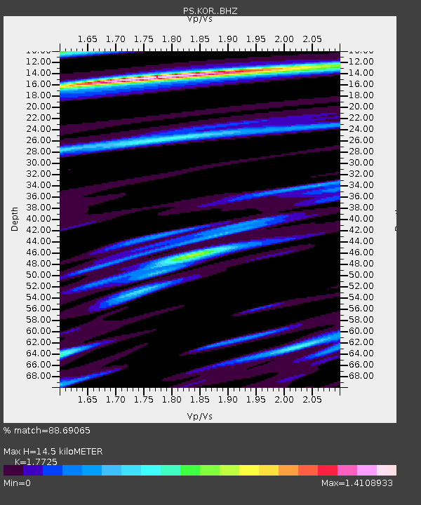
| Estimated Moho Depth: |
14.5 km |
| Estimated Crust Vp/Vs: |
1.77 |
| Assumed Crust Vp: |
4.24 km/s |
| Estimated Crust Vs: |
2.392 km/s |
| Estimated Crust Poisson's Ratio: |
0.27 |
|
| Radial Match: |
88.69065 % |
| Radial Bump: |
375 |
| Transverse Match: |
77.110306 % |
| Transverse Bump: |
400 |
| SOD ConfigId: |
33437571 |
| Insert Time: |
2024-02-05 18:30:24.996 +0000 |
| GWidth: |
2.5 |
| Max Bumps: |
400 |
| Tol: |
0.001 |
|

Signal To Noise
| Channel | StoN | STA | LTA |
| PS:KOR: :BHZ:20240122T18:18:38.011006Z | 2.1507797 | 3.886242E-6 | 1.8068993E-6 |
| PS:KOR: :BHN:20240122T18:18:38.011006Z | 1.3505523 | 1.7279607E-6 | 1.2794474E-6 |
| PS:KOR: :BHE:20240122T18:18:38.011006Z | 1.3673147 | 1.6629834E-6 | 1.2162405E-6 |
| Arrivals |
| Ps | 2.7 SECOND |
| PpPs | 9.3 SECOND |
| PsPs/PpSs | 12 SECOND |


