You are here: Home > Network List > RV - Regional Alberta Seismic Observatory for Earthquake Studies Network Stations List
> Station REDDA Red Deer Airport, AB > Earthquake Result Viewer
REDDA Red Deer Airport, AB - Earthquake Result Viewer
| Earthquake location: |
Kyrgyzstan-Xinjiang Border Reg. |
| Earthquake latitude/longitude: |
41.3/78.6 |
| Earthquake time(UTC): |
2024/01/22 (022) 18:09:04 GMT |
| Earthquake Depth: |
13 km |
| Earthquake Magnitude: |
7.0 Mww |
| Earthquake Catalog/Contributor: |
NEIC PDE/us |
|
| Network: |
RV Regional Alberta Seismic Observatory for Earthquake Studies Network |
| Station: |
REDDA Red Deer Airport, AB |
| Lat/Lon: |
52.18 N/113.90 W |
| Elevation: |
892 m |
|
| Distance: |
86.3 deg |
| Az: |
7.707 deg |
| Baz: |
350.551 deg |
| Ray Param: |
0.044153616 |
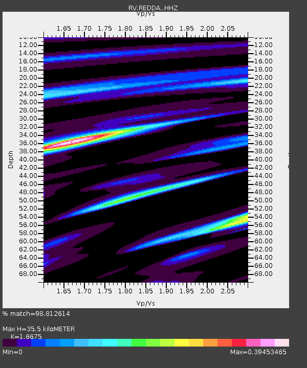
| Estimated Moho Depth: |
35.5 km |
| Estimated Crust Vp/Vs: |
1.67 |
| Assumed Crust Vp: |
6.483 km/s |
| Estimated Crust Vs: |
3.888 km/s |
| Estimated Crust Poisson's Ratio: |
0.22 |
|
| Radial Match: |
98.812614 % |
| Radial Bump: |
118 |
| Transverse Match: |
77.18753 % |
| Transverse Bump: |
400 |
| SOD ConfigId: |
33437571 |
| Insert Time: |
2024-02-05 18:30:54.776 +0000 |
| GWidth: |
2.5 |
| Max Bumps: |
400 |
| Tol: |
0.001 |
|

Signal To Noise
| Channel | StoN | STA | LTA |
| RV:REDDA: :HHZ:20240122T18:21:14.370015Z | 7.291851 | 6.8897816E-7 | 9.4486055E-8 |
| RV:REDDA: :HHN:20240122T18:21:14.370015Z | 5.1457233 | 1.0773165E-6 | 2.0936153E-7 |
| RV:REDDA: :HHE:20240122T18:21:14.370015Z | 1.2394654 | 5.572928E-7 | 4.4962354E-7 |
| Arrivals |
| Ps | 3.7 SECOND |
| PpPs | 14 SECOND |
| PsPs/PpSs | 18 SECOND |


