You are here: Home > Network List > TA - USArray Transportable Network (new EarthScope stations) Stations List
> Station O03D Paynes Creek, CA, USA > Earthquake Result Viewer
O03D Paynes Creek, CA, USA - Earthquake Result Viewer
| Earthquake location: |
Vanuatu Islands |
| Earthquake latitude/longitude: |
-20.7/169.8 |
| Earthquake time(UTC): |
2010/09/08 (251) 11:37:31 GMT |
| Earthquake Depth: |
10 km |
| Earthquake Magnitude: |
5.9 MB, 6.2 MS, 6.3 MW, 6.3 MW |
| Earthquake Catalog/Contributor: |
WHDF/NEIC |
|
| Network: |
TA USArray Transportable Network (new EarthScope stations) |
| Station: |
O03D Paynes Creek, CA, USA |
| Lat/Lon: |
40.29 N/121.80 W |
| Elevation: |
968 m |
|
| Distance: |
87.8 deg |
| Az: |
45.362 deg |
| Baz: |
240.592 deg |
| Ray Param: |
0.0430368 |
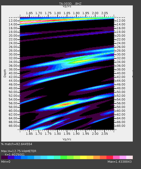
| Estimated Moho Depth: |
12.75 km |
| Estimated Crust Vp/Vs: |
1.60 |
| Assumed Crust Vp: |
6.566 km/s |
| Estimated Crust Vs: |
4.097 km/s |
| Estimated Crust Poisson's Ratio: |
0.18 |
|
| Radial Match: |
92.644554 % |
| Radial Bump: |
366 |
| Transverse Match: |
88.34981 % |
| Transverse Bump: |
400 |
| SOD ConfigId: |
319893 |
| Insert Time: |
2011-01-13 09:10:14.246 +0000 |
| GWidth: |
2.5 |
| Max Bumps: |
400 |
| Tol: |
0.001 |
|

Signal To Noise
| Channel | StoN | STA | LTA |
| TA:O03D: :BHZ:20100908T11:49:49.725022Z | 2.5187383 | 2.6740688E-7 | 1.0616699E-7 |
| TA:O03D: :BHN:20100908T11:49:49.725022Z | 2.148939 | 2.2429732E-7 | 1.0437585E-7 |
| TA:O03D: :BHE:20100908T11:49:49.725022Z | 1.7955694 | 1.8066936E-7 | 1.0061954E-7 |
| Arrivals |
| Ps | 1.2 SECOND |
| PpPs | 4.9 SECOND |
| PsPs/PpSs | 6.1 SECOND |


