You are here: Home > Network List > UW - Pacific Northwest Regional Seismic Network Stations List
> Station GUEM Guemes Island, WA, USA > Earthquake Result Viewer
GUEM Guemes Island, WA, USA - Earthquake Result Viewer
| Earthquake location: |
Kyrgyzstan-Xinjiang Border Reg. |
| Earthquake latitude/longitude: |
41.3/78.6 |
| Earthquake time(UTC): |
2024/01/22 (022) 18:09:04 GMT |
| Earthquake Depth: |
13 km |
| Earthquake Magnitude: |
7.0 Mww |
| Earthquake Catalog/Contributor: |
NEIC PDE/us |
|
| Network: |
UW Pacific Northwest Regional Seismic Network |
| Station: |
GUEM Guemes Island, WA, USA |
| Lat/Lon: |
48.55 N/122.63 W |
| Elevation: |
52 m |
|
| Distance: |
88.6 deg |
| Az: |
13.959 deg |
| Baz: |
344.119 deg |
| Ray Param: |
0.042454604 |
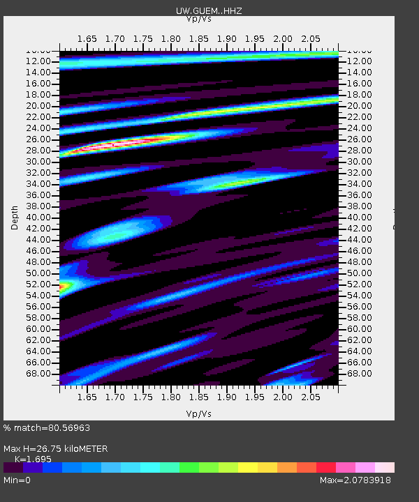
| Estimated Moho Depth: |
26.75 km |
| Estimated Crust Vp/Vs: |
1.70 |
| Assumed Crust Vp: |
6.566 km/s |
| Estimated Crust Vs: |
3.874 km/s |
| Estimated Crust Poisson's Ratio: |
0.23 |
|
| Radial Match: |
80.56963 % |
| Radial Bump: |
400 |
| Transverse Match: |
76.35834 % |
| Transverse Bump: |
400 |
| SOD ConfigId: |
33437571 |
| Insert Time: |
2024-02-05 18:35:04.239 +0000 |
| GWidth: |
2.5 |
| Max Bumps: |
400 |
| Tol: |
0.001 |
|

Signal To Noise
| Channel | StoN | STA | LTA |
| UW:GUEM: :HHZ:20240122T18:21:25.510029Z | 4.2135544 | 1.8517766E-6 | 4.3948086E-7 |
| UW:GUEM: :HHN:20240122T18:21:25.510029Z | 1.1046152 | 9.754666E-7 | 8.8308275E-7 |
| UW:GUEM: :HHE:20240122T18:21:25.510029Z | 1.4364158 | 1.0218788E-6 | 7.114088E-7 |
| Arrivals |
| Ps | 2.9 SECOND |
| PpPs | 11 SECOND |
| PsPs/PpSs | 14 SECOND |


