You are here: Home > Network List > UW - Pacific Northwest Regional Seismic Network Stations List
> Station HOOD Mt Hood Meadows, OR CREST BB SMO > Earthquake Result Viewer
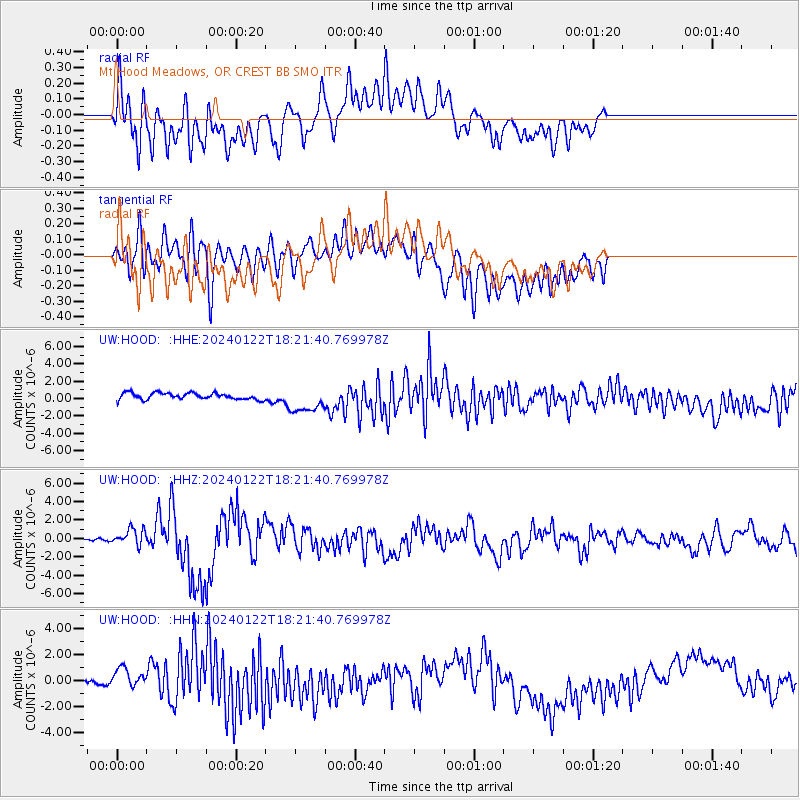
HOOD Mt Hood Meadows, OR CREST BB SMO - Earthquake Result Viewer
*The percent match for this event was below the threshold and hence no stack was calculated.
| Earthquake location: |
Kyrgyzstan-Xinjiang Border Reg. |
| Earthquake latitude/longitude: |
41.3/78.6 |
| Earthquake time(UTC): |
2024/01/22 (022) 18:09:04 GMT |
| Earthquake Depth: |
13 km |
| Earthquake Magnitude: |
7.0 Mww |
| Earthquake Catalog/Contributor: |
NEIC PDE/us |
|
| Network: |
UW Pacific Northwest Regional Seismic Network |
| Station: |
HOOD Mt Hood Meadows, OR CREST BB SMO |
| Lat/Lon: |
45.32 N/121.65 W |
| Elevation: |
1520 m |
|
| Distance: |
91.9 deg |
| Az: |
14.178 deg |
| Baz: |
344.829 deg |
| Ray Param: |
$rayparam |
*The percent match for this event was below the threshold and hence was not used in the summary stack. |
|
| Radial Match: |
77.436005 % |
| Radial Bump: |
400 |
| Transverse Match: |
67.78476 % |
| Transverse Bump: |
400 |
| SOD ConfigId: |
33437571 |
| Insert Time: |
2024-02-05 18:35:13.762 +0000 |
| GWidth: |
2.5 |
| Max Bumps: |
400 |
| Tol: |
0.001 |
|
Signal To Noise
| Channel | StoN | STA | LTA |
| UW:HOOD: :HHZ:20240122T18:21:40.769978Z | 3.7613428 | 9.21368E-7 | 2.449572E-7 |
| UW:HOOD: :HHN:20240122T18:21:40.769978Z | 1.9309735 | 9.157955E-7 | 4.7426622E-7 |
| UW:HOOD: :HHE:20240122T18:21:40.769978Z | 3.9942675 | 1.5307351E-6 | 3.83233E-7 |
| Arrivals |
| Ps | |
| PpPs | |
| PsPs/PpSs | |


