You are here: Home > Network List > UW - Pacific Northwest Regional Seismic Network Stations List
> Station UMAT Pilot Rock, OR, USA > Earthquake Result Viewer
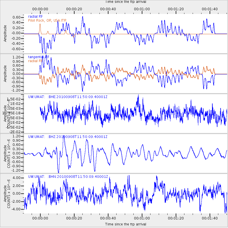
UMAT Pilot Rock, OR, USA - Earthquake Result Viewer
*The percent match for this event was below the threshold and hence no stack was calculated.
| Earthquake location: |
Vanuatu Islands |
| Earthquake latitude/longitude: |
-20.7/169.8 |
| Earthquake time(UTC): |
2010/09/08 (251) 11:37:31 GMT |
| Earthquake Depth: |
10 km |
| Earthquake Magnitude: |
5.9 MB, 6.2 MS, 6.3 MW, 6.3 MW |
| Earthquake Catalog/Contributor: |
WHDF/NEIC |
|
| Network: |
UW Pacific Northwest Regional Seismic Network |
| Station: |
UMAT Pilot Rock, OR, USA |
| Lat/Lon: |
45.29 N/118.96 W |
| Elevation: |
1318 m |
|
| Distance: |
92.1 deg |
| Az: |
41.971 deg |
| Baz: |
242.515 deg |
| Ray Param: |
$rayparam |
*The percent match for this event was below the threshold and hence was not used in the summary stack. |
|
| Radial Match: |
62.634502 % |
| Radial Bump: |
400 |
| Transverse Match: |
62.63296 % |
| Transverse Bump: |
400 |
| SOD ConfigId: |
319893 |
| Insert Time: |
2011-01-13 09:12:08.161 +0000 |
| GWidth: |
2.5 |
| Max Bumps: |
400 |
| Tol: |
0.001 |
|
Signal To Noise
| Channel | StoN | STA | LTA |
| UW:UMAT: :BHZ:20100908T11:50:09.40001Z | 2.0773618 | 1.8207007E-7 | 8.764485E-8 |
| UW:UMAT: :BHN:20100908T11:50:09.40001Z | 1.1691287 | 1.9418208E-6 | 1.6609129E-6 |
| UW:UMAT: :BHE:20100908T11:50:09.40001Z | 1.1011925 | 5.227317E-9 | 4.74696E-9 |
| Arrivals |
| Ps | |
| PpPs | |
| PsPs/PpSs | |


