You are here: Home > Network List > UW - Pacific Northwest Regional Seismic Network Stations List
> Station TNSKT Tonasket, WA, USA > Earthquake Result Viewer
TNSKT Tonasket, WA, USA - Earthquake Result Viewer
| Earthquake location: |
Kyrgyzstan-Xinjiang Border Reg. |
| Earthquake latitude/longitude: |
41.3/78.6 |
| Earthquake time(UTC): |
2024/01/22 (022) 18:09:04 GMT |
| Earthquake Depth: |
13 km |
| Earthquake Magnitude: |
7.0 Mww |
| Earthquake Catalog/Contributor: |
NEIC PDE/us |
|
| Network: |
UW Pacific Northwest Regional Seismic Network |
| Station: |
TNSKT Tonasket, WA, USA |
| Lat/Lon: |
48.72 N/119.44 W |
| Elevation: |
395 m |
|
| Distance: |
89.0 deg |
| Az: |
11.869 deg |
| Baz: |
346.46 deg |
| Ray Param: |
0.04218736 |
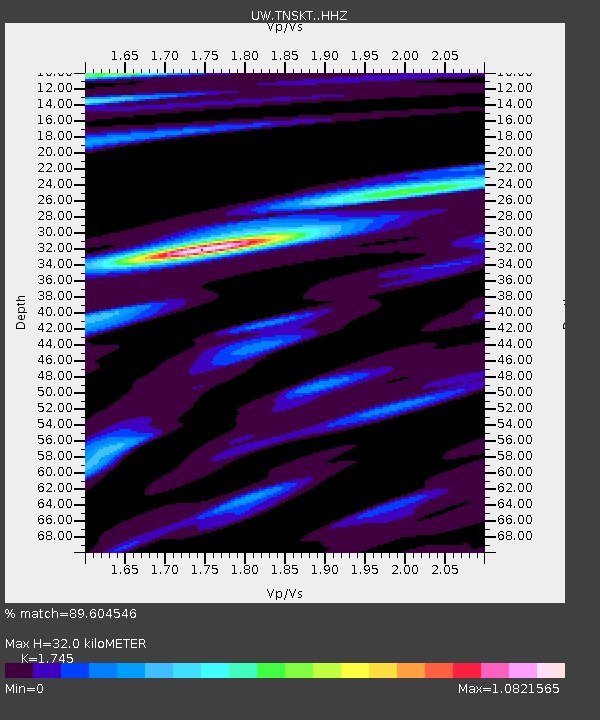
| Estimated Moho Depth: |
32.0 km |
| Estimated Crust Vp/Vs: |
1.75 |
| Assumed Crust Vp: |
6.419 km/s |
| Estimated Crust Vs: |
3.679 km/s |
| Estimated Crust Poisson's Ratio: |
0.26 |
|
| Radial Match: |
89.604546 % |
| Radial Bump: |
366 |
| Transverse Match: |
78.17721 % |
| Transverse Bump: |
400 |
| SOD ConfigId: |
33437571 |
| Insert Time: |
2024-02-05 18:37:05.569 +0000 |
| GWidth: |
2.5 |
| Max Bumps: |
400 |
| Tol: |
0.001 |
|

Signal To Noise
| Channel | StoN | STA | LTA |
| UW:TNSKT: :HHZ:20240122T18:21:27.24001Z | 9.502162 | 1.4820688E-6 | 1.5597175E-7 |
| UW:TNSKT: :HHN:20240122T18:21:27.24001Z | 2.3279486 | 5.4868707E-7 | 2.3569554E-7 |
| UW:TNSKT: :HHE:20240122T18:21:27.24001Z | 1.8302728 | 3.46764E-7 | 1.894603E-7 |
| Arrivals |
| Ps | 3.8 SECOND |
| PpPs | 13 SECOND |
| PsPs/PpSs | 17 SECOND |


