You are here: Home > Network List > 1E - GSC-BCOGC Induced Seismicity Study Stations List
> Station MONTC Z > Earthquake Result Viewer
MONTC Z - Earthquake Result Viewer
| Earthquake location: |
Kyrgyzstan-Xinjiang Border Reg. |
| Earthquake latitude/longitude: |
41.3/78.6 |
| Earthquake time(UTC): |
2024/01/22 (022) 18:14:16 GMT |
| Earthquake Depth: |
10 km |
| Earthquake Magnitude: |
5.8 mb |
| Earthquake Catalog/Contributor: |
NEIC PDE/us |
|
| Network: |
1E GSC-BCOGC Induced Seismicity Study |
| Station: |
MONTC Z |
| Lat/Lon: |
57.13 N/122.76 W |
| Elevation: |
0.0 m |
|
| Distance: |
80.3 deg |
| Az: |
11.628 deg |
| Baz: |
343.826 deg |
| Ray Param: |
0.048375804 |
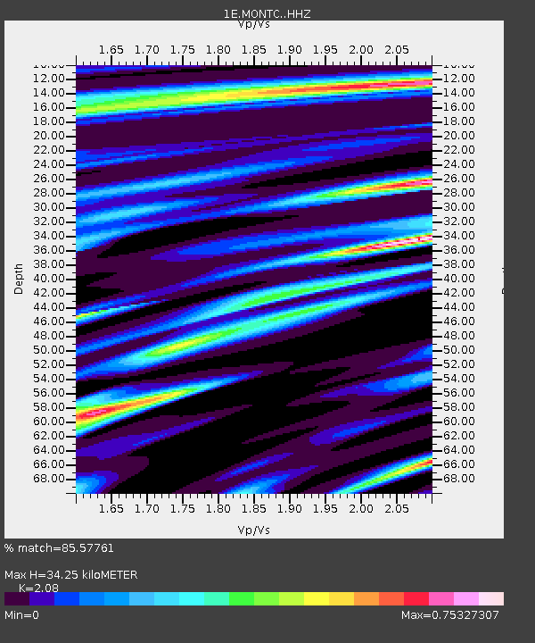
| Estimated Moho Depth: |
34.25 km |
| Estimated Crust Vp/Vs: |
2.08 |
| Assumed Crust Vp: |
6.232 km/s |
| Estimated Crust Vs: |
2.996 km/s |
| Estimated Crust Poisson's Ratio: |
0.35 |
|
| Radial Match: |
85.57761 % |
| Radial Bump: |
400 |
| Transverse Match: |
54.638622 % |
| Transverse Bump: |
400 |
| SOD ConfigId: |
33437571 |
| Insert Time: |
2024-02-05 18:39:22.775 +0000 |
| GWidth: |
2.5 |
| Max Bumps: |
400 |
| Tol: |
0.001 |
|

Signal To Noise
| Channel | StoN | STA | LTA |
| 1E:MONTC: :HHZ:20240122T18:25:55.860028Z | 2.2549477 | 2.4311191E-6 | 1.0781266E-6 |
| 1E:MONTC: :HHN:20240122T18:25:55.860028Z | 2.231354 | 2.121419E-6 | 9.507316E-7 |
| 1E:MONTC: :HHE:20240122T18:25:55.860028Z | 1.1128628 | 8.497849E-7 | 7.636025E-7 |
| Arrivals |
| Ps | 6.1 SECOND |
| PpPs | 17 SECOND |
| PsPs/PpSs | 23 SECOND |


