You are here: Home > Network List > AK - Alaska Regional Network Stations List
> Station S32K Killisnoo, AK, USA > Earthquake Result Viewer
S32K Killisnoo, AK, USA - Earthquake Result Viewer
| Earthquake location: |
Kyrgyzstan-Xinjiang Border Reg. |
| Earthquake latitude/longitude: |
41.3/78.6 |
| Earthquake time(UTC): |
2024/01/22 (022) 18:14:16 GMT |
| Earthquake Depth: |
10 km |
| Earthquake Magnitude: |
5.8 mb |
| Earthquake Catalog/Contributor: |
NEIC PDE/us |
|
| Network: |
AK Alaska Regional Network |
| Station: |
S32K Killisnoo, AK, USA |
| Lat/Lon: |
57.47 N/134.58 W |
| Elevation: |
26 m |
|
| Distance: |
77.7 deg |
| Az: |
17.617 deg |
| Baz: |
335.036 deg |
| Ray Param: |
0.050132353 |
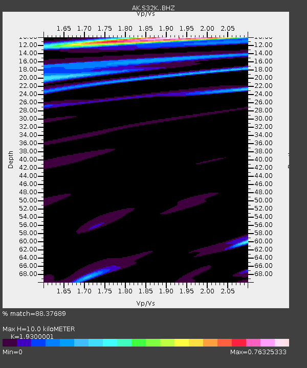
| Estimated Moho Depth: |
10.0 km |
| Estimated Crust Vp/Vs: |
1.93 |
| Assumed Crust Vp: |
6.472 km/s |
| Estimated Crust Vs: |
3.353 km/s |
| Estimated Crust Poisson's Ratio: |
0.32 |
|
| Radial Match: |
88.37689 % |
| Radial Bump: |
400 |
| Transverse Match: |
44.194817 % |
| Transverse Bump: |
400 |
| SOD ConfigId: |
33437571 |
| Insert Time: |
2024-02-05 18:41:10.787 +0000 |
| GWidth: |
2.5 |
| Max Bumps: |
400 |
| Tol: |
0.001 |
|

Signal To Noise
| Channel | StoN | STA | LTA |
| AK:S32K: :BHZ:20240122T18:25:41.860028Z | 1.7508748 | 3.7146608E-6 | 2.1216028E-6 |
| AK:S32K: :BHN:20240122T18:25:41.860028Z | 2.051019 | 2.9120508E-6 | 1.4198068E-6 |
| AK:S32K: :BHE:20240122T18:25:41.860028Z | 1.2530316 | 2.1619733E-6 | 1.725394E-6 |
| Arrivals |
| Ps | 1.5 SECOND |
| PpPs | 4.4 SECOND |
| PsPs/PpSs | 5.9 SECOND |


