You are here: Home > Network List > AK - Alaska Regional Network Stations List
> Station U33K Whale Pass, AK, USA > Earthquake Result Viewer
U33K Whale Pass, AK, USA - Earthquake Result Viewer
| Earthquake location: |
Kyrgyzstan-Xinjiang Border Reg. |
| Earthquake latitude/longitude: |
41.3/78.6 |
| Earthquake time(UTC): |
2024/01/22 (022) 18:14:16 GMT |
| Earthquake Depth: |
10 km |
| Earthquake Magnitude: |
5.8 mb |
| Earthquake Catalog/Contributor: |
NEIC PDE/us |
|
| Network: |
AK Alaska Regional Network |
| Station: |
U33K Whale Pass, AK, USA |
| Lat/Lon: |
56.11 N/133.12 W |
| Elevation: |
11 m |
|
| Distance: |
79.3 deg |
| Az: |
17.444 deg |
| Baz: |
336.216 deg |
| Ray Param: |
0.04906053 |
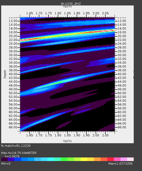
| Estimated Moho Depth: |
16.75 km |
| Estimated Crust Vp/Vs: |
2.09 |
| Assumed Crust Vp: |
6.597 km/s |
| Estimated Crust Vs: |
3.16 km/s |
| Estimated Crust Poisson's Ratio: |
0.35 |
|
| Radial Match: |
91.12228 % |
| Radial Bump: |
287 |
| Transverse Match: |
53.611095 % |
| Transverse Bump: |
400 |
| SOD ConfigId: |
33437571 |
| Insert Time: |
2024-02-05 18:41:16.606 +0000 |
| GWidth: |
2.5 |
| Max Bumps: |
400 |
| Tol: |
0.001 |
|

Signal To Noise
| Channel | StoN | STA | LTA |
| AK:U33K: :BHZ:20240122T18:25:50.480023Z | 2.1700265 | 2.3444302E-6 | 1.0803693E-6 |
| AK:U33K: :BHN:20240122T18:25:50.480023Z | 3.5638392 | 2.3626685E-6 | 6.629559E-7 |
| AK:U33K: :BHE:20240122T18:25:50.480023Z | 2.8872046 | 1.2000706E-6 | 4.1565136E-7 |
| Arrivals |
| Ps | 2.8 SECOND |
| PpPs | 7.6 SECOND |
| PsPs/PpSs | 10 SECOND |


