You are here: Home > Network List > US - United States National Seismic Network Stations List
> Station MSO Missoula, Montana, USA > Earthquake Result Viewer
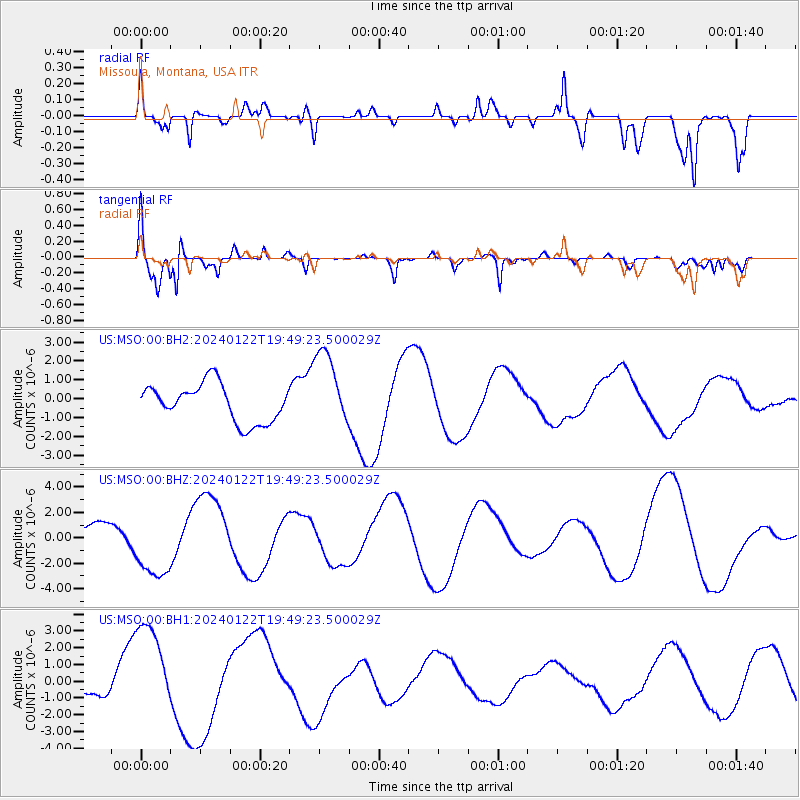
MSO Missoula, Montana, USA - Earthquake Result Viewer
*The percent match for this event was below the threshold and hence no stack was calculated.
| Earthquake location: |
Kyrgyzstan-Xinjiang Border Reg. |
| Earthquake latitude/longitude: |
41.2/78.6 |
| Earthquake time(UTC): |
2024/01/22 (022) 19:36:47 GMT |
| Earthquake Depth: |
10 km |
| Earthquake Magnitude: |
5.5 mb |
| Earthquake Catalog/Contributor: |
NEIC PDE/us |
|
| Network: |
US United States National Seismic Network |
| Station: |
MSO Missoula, Montana, USA |
| Lat/Lon: |
46.83 N/113.94 W |
| Elevation: |
1264 m |
|
| Distance: |
91.6 deg |
| Az: |
8.589 deg |
| Baz: |
350.553 deg |
| Ray Param: |
$rayparam |
*The percent match for this event was below the threshold and hence was not used in the summary stack. |
|
| Radial Match: |
38.841736 % |
| Radial Bump: |
400 |
| Transverse Match: |
77.83867 % |
| Transverse Bump: |
400 |
| SOD ConfigId: |
33437571 |
| Insert Time: |
2024-02-05 19:53:18.480 +0000 |
| GWidth: |
2.5 |
| Max Bumps: |
400 |
| Tol: |
0.001 |
|
Signal To Noise
| Channel | StoN | STA | LTA |
| US:MSO:00:BHZ:20240122T19:49:23.500029Z | 4.100671 | 2.6344717E-6 | 6.42449E-7 |
| US:MSO:00:BH1:20240122T19:49:23.500029Z | 2.4711363 | 2.9389446E-6 | 1.1893089E-6 |
| US:MSO:00:BH2:20240122T19:49:23.500029Z | 2.0796797 | 2.0805455E-6 | 1.0004163E-6 |
| Arrivals |
| Ps | |
| PpPs | |
| PsPs/PpSs | |


