You are here: Home > Network List > TA - USArray Transportable Network (new EarthScope stations) Stations List
> Station R26A Arlington, CO, USA > Earthquake Result Viewer
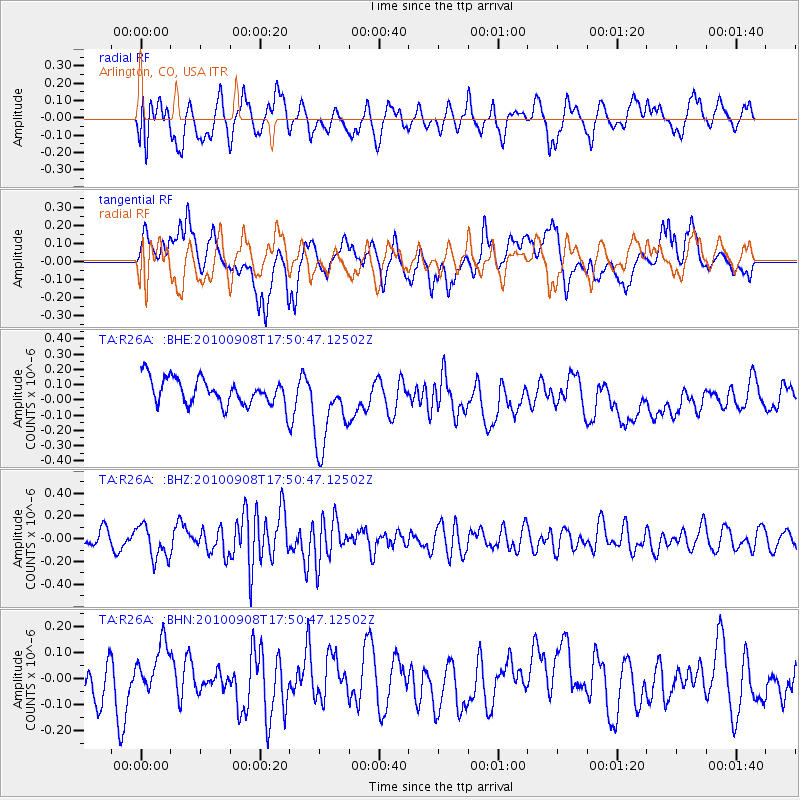
R26A Arlington, CO, USA - Earthquake Result Viewer
*The percent match for this event was below the threshold and hence no stack was calculated.
| Earthquake location: |
Kuril Islands |
| Earthquake latitude/longitude: |
44.6/149.7 |
| Earthquake time(UTC): |
2010/09/08 (251) 17:39:40 GMT |
| Earthquake Depth: |
10 km |
| Earthquake Magnitude: |
5.5 MB, 5.3 MS, 5.5 MW |
| Earthquake Catalog/Contributor: |
WHDF/NEIC |
|
| Network: |
TA USArray Transportable Network (new EarthScope stations) |
| Station: |
R26A Arlington, CO, USA |
| Lat/Lon: |
38.30 N/103.45 W |
| Elevation: |
1304 m |
|
| Distance: |
74.4 deg |
| Az: |
51.437 deg |
| Baz: |
314.756 deg |
| Ray Param: |
$rayparam |
*The percent match for this event was below the threshold and hence was not used in the summary stack. |
|
| Radial Match: |
38.770813 % |
| Radial Bump: |
400 |
| Transverse Match: |
52.535816 % |
| Transverse Bump: |
400 |
| SOD ConfigId: |
319893 |
| Insert Time: |
2011-01-13 09:20:55.243 +0000 |
| GWidth: |
2.5 |
| Max Bumps: |
400 |
| Tol: |
0.001 |
|
Signal To Noise
| Channel | StoN | STA | LTA |
| TA:R26A: :BHZ:20100908T17:50:47.12502Z | 1.915478 | 1.4672376E-7 | 7.6599036E-8 |
| TA:R26A: :BHN:20100908T17:50:47.12502Z | 1.1974056 | 9.064772E-8 | 7.570344E-8 |
| TA:R26A: :BHE:20100908T17:50:47.12502Z | 3.0624743 | 2.638246E-7 | 8.614754E-8 |
| Arrivals |
| Ps | |
| PpPs | |
| PsPs/PpSs | |


