You are here: Home > Network List > G - GEOSCOPE Stations List
> Station TAM Tamanrasset, Algeria > Earthquake Result Viewer
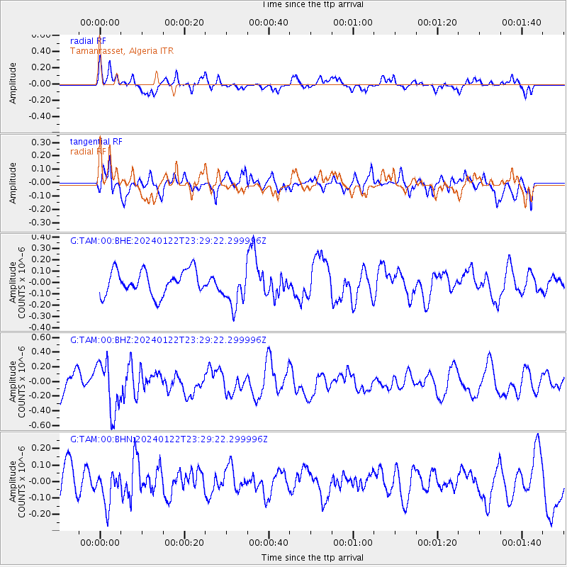
TAM Tamanrasset, Algeria - Earthquake Result Viewer
*The percent match for this event was below the threshold and hence no stack was calculated.
| Earthquake location: |
Kyrgyzstan-Xinjiang Border Reg. |
| Earthquake latitude/longitude: |
41.2/78.7 |
| Earthquake time(UTC): |
2024/01/22 (022) 23:19:26 GMT |
| Earthquake Depth: |
10 km |
| Earthquake Magnitude: |
5.6 mb |
| Earthquake Catalog/Contributor: |
NEIC PDE/us |
|
| Network: |
G GEOSCOPE |
| Station: |
TAM Tamanrasset, Algeria |
| Lat/Lon: |
22.79 N/5.53 E |
| Elevation: |
1377 m |
|
| Distance: |
63.0 deg |
| Az: |
277.445 deg |
| Baz: |
54.151 deg |
| Ray Param: |
$rayparam |
*The percent match for this event was below the threshold and hence was not used in the summary stack. |
|
| Radial Match: |
62.644535 % |
| Radial Bump: |
400 |
| Transverse Match: |
70.86561 % |
| Transverse Bump: |
400 |
| SOD ConfigId: |
33437571 |
| Insert Time: |
2024-02-05 23:28:00.343 +0000 |
| GWidth: |
2.5 |
| Max Bumps: |
400 |
| Tol: |
0.001 |
|
Signal To Noise
| Channel | StoN | STA | LTA |
| G:TAM:00:BHZ:20240122T23:29:22.299996Z | 2.2716424 | 3.4639314E-7 | 1.5248577E-7 |
| G:TAM:00:BHN:20240122T23:29:22.299996Z | 0.9928423 | 1.02723575E-7 | 1.0346414E-7 |
| G:TAM:00:BHE:20240122T23:29:22.299996Z | 1.561833 | 1.6675284E-7 | 1.0676739E-7 |
| Arrivals |
| Ps | |
| PpPs | |
| PsPs/PpSs | |


