You are here: Home > Network List > XG92 - Rocky Mountain Front Stations List
> Station CES Colby, Kansas > Earthquake Result Viewer
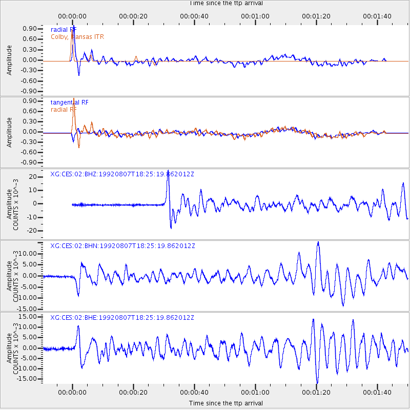
CES Colby, Kansas - Earthquake Result Viewer

| Earthquake location: |
Gulf Of Alaska |
| Earthquake latitude/longitude: |
57.6/-143.0 |
| Earthquake time(UTC): |
1992/08/07 (220) 18:19:19 GMT |
| Earthquake Depth: |
10 km |
| Earthquake Magnitude: |
6.3 MB, 6.5 MS, 6.5 ML |
| Earthquake Catalog/Contributor: |
WHDF/NEIC |
|
| Network: |
XG Rocky Mountain Front |
| Station: |
CES Colby, Kansas |
| Lat/Lon: |
39.39 N/101.07 W |
| Elevation: |
955 m |
|
| Distance: |
32.6 deg |
| Az: |
105.647 deg |
| Baz: |
318.012 deg |
| Ray Param: |
0.0785981 |
| Estimated Moho Depth: |
22.75 km |
| Estimated Crust Vp/Vs: |
2.08 |
| Assumed Crust Vp: |
6.483 km/s |
| Estimated Crust Vs: |
3.117 km/s |
| Estimated Crust Poisson's Ratio: |
0.35 |
|
| Radial Match: |
91.228905 % |
| Radial Bump: |
400 |
| Transverse Match: |
74.37578 % |
| Transverse Bump: |
400 |
| SOD ConfigId: |
3286 |
| Insert Time: |
2010-02-25 20:08:08.072 +0000 |
| GWidth: |
2.5 |
| Max Bumps: |
400 |
| Tol: |
0.001 |
|
Signal To Noise
| Channel | StoN | STA | LTA |
| XG:CES:02:BHN:19920807T18:25:19.862012Z | 15.647299 | 0.0039310884 | 2.512311E-4 |
| XG:CES:02:BHE:19920807T18:25:19.862012Z | 17.00001 | 0.0055889837 | 3.2876356E-4 |
| XG:CES:02:BHZ:19920807T18:25:19.862012Z | 34.705246 | 0.010734298 | 3.0929904E-4 |
| Arrivals |
| Ps | 4.1 SECOND |
| PpPs | 10 SECOND |
| PsPs/PpSs | 14 SECOND |


