You are here: Home > Network List > TA - USArray Transportable Network (new EarthScope stations) Stations List
> Station 334A Lometa, TX, USA > Earthquake Result Viewer
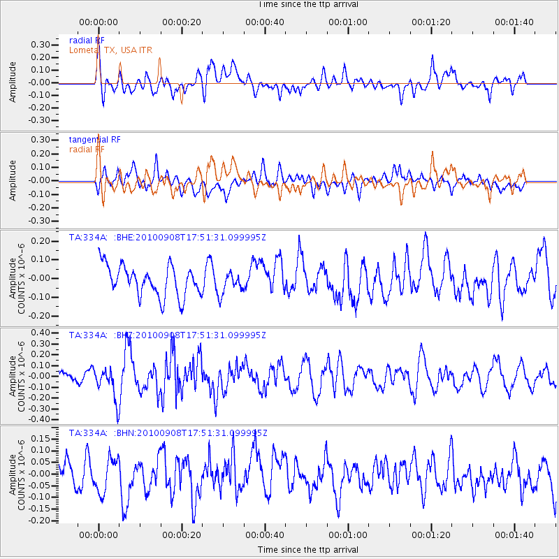
334A Lometa, TX, USA - Earthquake Result Viewer
*The percent match for this event was below the threshold and hence no stack was calculated.
| Earthquake location: |
Kuril Islands |
| Earthquake latitude/longitude: |
44.6/149.7 |
| Earthquake time(UTC): |
2010/09/08 (251) 17:39:40 GMT |
| Earthquake Depth: |
10 km |
| Earthquake Magnitude: |
5.5 MB, 5.3 MS, 5.5 MW |
| Earthquake Catalog/Contributor: |
WHDF/NEIC |
|
| Network: |
TA USArray Transportable Network (new EarthScope stations) |
| Station: |
334A Lometa, TX, USA |
| Lat/Lon: |
31.33 N/98.24 W |
| Elevation: |
389 m |
|
| Distance: |
82.4 deg |
| Az: |
53.154 deg |
| Baz: |
318.07 deg |
| Ray Param: |
$rayparam |
*The percent match for this event was below the threshold and hence was not used in the summary stack. |
|
| Radial Match: |
57.27037 % |
| Radial Bump: |
400 |
| Transverse Match: |
41.23562 % |
| Transverse Bump: |
400 |
| SOD ConfigId: |
319893 |
| Insert Time: |
2011-01-13 09:24:57.081 +0000 |
| GWidth: |
2.5 |
| Max Bumps: |
400 |
| Tol: |
0.001 |
|
Signal To Noise
| Channel | StoN | STA | LTA |
| TA:334A: :BHZ:20100908T17:51:31.099995Z | 1.9974886 | 1.5228721E-7 | 7.623934E-8 |
| TA:334A: :BHN:20100908T17:51:31.099995Z | 1.1806856 | 7.372818E-8 | 6.2445224E-8 |
| TA:334A: :BHE:20100908T17:51:31.099995Z | 0.68039197 | 5.5346632E-8 | 8.134522E-8 |
| Arrivals |
| Ps | |
| PpPs | |
| PsPs/PpSs | |


