You are here: Home > Network List > IU - Global Seismograph Network (GSN - IRIS/USGS) Stations List
> Station NWAO Narrogin, Australia > Earthquake Result Viewer
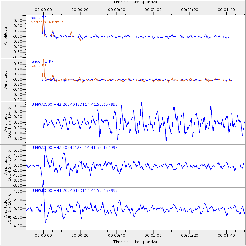
NWAO Narrogin, Australia - Earthquake Result Viewer
| Earthquake location: |
Vanuatu Islands |
| Earthquake latitude/longitude: |
-17.9/167.8 |
| Earthquake time(UTC): |
2024/01/23 (023) 14:33:47 GMT |
| Earthquake Depth: |
10 km |
| Earthquake Magnitude: |
6.5 Mi |
| Earthquake Catalog/Contributor: |
NEIC PDE/at |
|
| Network: |
IU Global Seismograph Network (GSN - IRIS/USGS) |
| Station: |
NWAO Narrogin, Australia |
| Lat/Lon: |
32.93 S/117.24 E |
| Elevation: |
380 m |
|
| Distance: |
47.6 deg |
| Az: |
241.549 deg |
| Baz: |
84.537 deg |
| Ray Param: |
0.06988395 |
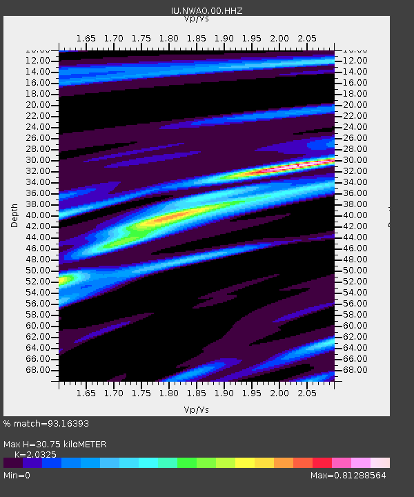
| Estimated Moho Depth: |
30.75 km |
| Estimated Crust Vp/Vs: |
2.03 |
| Assumed Crust Vp: |
6.419 km/s |
| Estimated Crust Vs: |
3.158 km/s |
| Estimated Crust Poisson's Ratio: |
0.34 |
|
| Radial Match: |
93.16393 % |
| Radial Bump: |
212 |
| Transverse Match: |
65.76318 % |
| Transverse Bump: |
400 |
| SOD ConfigId: |
33437571 |
| Insert Time: |
2024-02-06 14:49:09.951 +0000 |
| GWidth: |
2.5 |
| Max Bumps: |
400 |
| Tol: |
0.001 |
|
Signal To Noise
| Channel | StoN | STA | LTA |
| IU:NWAO:00:HHZ:20240123T14:41:52.15799Z | 14.078957 | 4.2480356E-6 | 3.0172944E-7 |
| IU:NWAO:00:HH1:20240123T14:41:52.15799Z | 14.681615 | 2.3425096E-6 | 1.5955395E-7 |
| IU:NWAO:00:HH2:20240123T14:41:52.15799Z | 2.1330752 | 3.6004468E-7 | 1.6879136E-7 |
| Arrivals |
| Ps | 5.2 SECOND |
| PpPs | 14 SECOND |
| PsPs/PpSs | 19 SECOND |


