You are here: Home > Network List > XG92 - Rocky Mountain Front Stations List
> Station CES Colby, Kansas > Earthquake Result Viewer
CES Colby, Kansas - Earthquake Result Viewer

| Earthquake location: |
South Of Fiji Islands |
| Earthquake latitude/longitude: |
-22.3/-178.5 |
| Earthquake time(UTC): |
1992/07/11 (193) 10:44:20 GMT |
| Earthquake Depth: |
381 km |
| Earthquake Magnitude: |
6.2 MB |
| Earthquake Catalog/Contributor: |
WHDF/NEIC |
|
| Network: |
XG Rocky Mountain Front |
| Station: |
CES Colby, Kansas |
| Lat/Lon: |
39.39 N/101.07 W |
| Elevation: |
955 m |
|
| Distance: |
94.7 deg |
| Az: |
49.369 deg |
| Baz: |
245.11 deg |
| Ray Param: |
0.04063649 |
| Estimated Moho Depth: |
32.75 km |
| Estimated Crust Vp/Vs: |
1.86 |
| Assumed Crust Vp: |
6.483 km/s |
| Estimated Crust Vs: |
3.495 km/s |
| Estimated Crust Poisson's Ratio: |
0.30 |
|
| Radial Match: |
94.394875 % |
| Radial Bump: |
214 |
| Transverse Match: |
75.74462 % |
| Transverse Bump: |
400 |
| SOD ConfigId: |
3286 |
| Insert Time: |
2010-02-25 20:08:09.518 +0000 |
| GWidth: |
2.5 |
| Max Bumps: |
400 |
| Tol: |
0.001 |
|
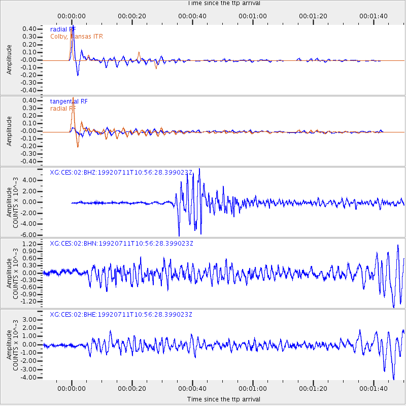
Signal To Noise
| Channel | StoN | STA | LTA |
| XG:CES:02:BHN:19920711T10:56:28.399023Z | 1.2951468 | 1.0419017E-4 | 8.044661E-5 |
| XG:CES:02:BHE:19920711T10:56:28.399023Z | 1.0099188 | 1.06744395E-4 | 1.0569601E-4 |
| XG:CES:02:BHZ:19920711T10:56:28.399023Z | 5.0814853 | 4.4348938E-4 | 8.727553E-5 |
| Arrivals |
| Ps | 4.4 SECOND |
| PpPs | 14 SECOND |
| PsPs/PpSs | 19 SECOND |


