You are here: Home > Network List > UW - Pacific Northwest Regional Seismic Network Stations List
> Station UMAT Pilot Rock, OR, USA > Earthquake Result Viewer
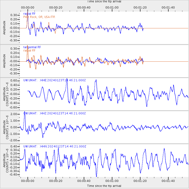
UMAT Pilot Rock, OR, USA - Earthquake Result Viewer
*The percent match for this event was below the threshold and hence no stack was calculated.
| Earthquake location: |
Vanuatu Islands |
| Earthquake latitude/longitude: |
-17.9/167.8 |
| Earthquake time(UTC): |
2024/01/23 (023) 14:33:47 GMT |
| Earthquake Depth: |
10 km |
| Earthquake Magnitude: |
6.5 Mi |
| Earthquake Catalog/Contributor: |
NEIC PDE/at |
|
| Network: |
UW Pacific Northwest Regional Seismic Network |
| Station: |
UMAT Pilot Rock, OR, USA |
| Lat/Lon: |
45.29 N/118.96 W |
| Elevation: |
1318 m |
|
| Distance: |
91.3 deg |
| Az: |
42.538 deg |
| Baz: |
245.781 deg |
| Ray Param: |
$rayparam |
*The percent match for this event was below the threshold and hence was not used in the summary stack. |
|
| Radial Match: |
67.17457 % |
| Radial Bump: |
364 |
| Transverse Match: |
61.657276 % |
| Transverse Bump: |
400 |
| SOD ConfigId: |
33437571 |
| Insert Time: |
2024-02-06 15:00:08.122 +0000 |
| GWidth: |
2.5 |
| Max Bumps: |
400 |
| Tol: |
0.001 |
|
Signal To Noise
| Channel | StoN | STA | LTA |
| UW:UMAT: :HHZ:20240123T14:46:21.000Z | 2.8422015 | 4.5350325E-7 | 1.5956056E-7 |
| UW:UMAT: :HHN:20240123T14:46:21.000Z | 1.2714221 | 1.2880554E-7 | 1.0130824E-7 |
| UW:UMAT: :HHE:20240123T14:46:21.000Z | 1.7558783 | 2.7006436E-7 | 1.5380586E-7 |
| Arrivals |
| Ps | |
| PpPs | |
| PsPs/PpSs | |


