You are here: Home > Network List > SC - New Mexico Tech Seismic Network Stations List
> Station Y22A Socorro, NM, USA > Earthquake Result Viewer
Y22A Socorro, NM, USA - Earthquake Result Viewer
| Earthquake location: |
Near Coast Of Central Chile |
| Earthquake latitude/longitude: |
-37.0/-73.4 |
| Earthquake time(UTC): |
2010/09/09 (252) 07:28:01 GMT |
| Earthquake Depth: |
16 km |
| Earthquake Magnitude: |
5.8 MB, 6.0 MS, 6.2 MW, 6.2 MW |
| Earthquake Catalog/Contributor: |
WHDF/NEIC |
|
| Network: |
SC New Mexico Tech Seismic Network |
| Station: |
Y22A Socorro, NM, USA |
| Lat/Lon: |
33.94 N/106.97 W |
| Elevation: |
1674 m |
|
| Distance: |
77.2 deg |
| Az: |
331.889 deg |
| Baz: |
153.03 deg |
| Ray Param: |
0.05045762 |
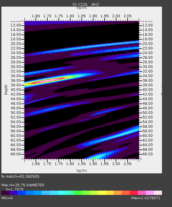
| Estimated Moho Depth: |
35.75 km |
| Estimated Crust Vp/Vs: |
1.71 |
| Assumed Crust Vp: |
6.502 km/s |
| Estimated Crust Vs: |
3.808 km/s |
| Estimated Crust Poisson's Ratio: |
0.24 |
|
| Radial Match: |
92.060585 % |
| Radial Bump: |
346 |
| Transverse Match: |
76.18595 % |
| Transverse Bump: |
400 |
| SOD ConfigId: |
319893 |
| Insert Time: |
2011-01-13 09:35:33.497 +0000 |
| GWidth: |
2.5 |
| Max Bumps: |
400 |
| Tol: |
0.001 |
|

Signal To Noise
| Channel | StoN | STA | LTA |
| SC:Y22A: :BHZ:20100909T07:39:23.524993Z | 1.7102766 | 1.6211361E-7 | 9.478795E-8 |
| SC:Y22A: :BHN:20100909T07:39:23.524993Z | 0.6656518 | 7.647379E-8 | 1.1488557E-7 |
| SC:Y22A: :BHE:20100909T07:39:23.524993Z | 1.9041232 | 2.2714323E-7 | 1.192902E-7 |
| Arrivals |
| Ps | 4.0 SECOND |
| PpPs | 14 SECOND |
| PsPs/PpSs | 18 SECOND |


