You are here: Home > Network List > TA - USArray Transportable Network (new EarthScope stations) Stations List
> Station T25A Trinidad, CO, USA > Earthquake Result Viewer
T25A Trinidad, CO, USA - Earthquake Result Viewer
| Earthquake location: |
Near Coast Of Central Chile |
| Earthquake latitude/longitude: |
-37.0/-73.4 |
| Earthquake time(UTC): |
2010/09/09 (252) 07:28:01 GMT |
| Earthquake Depth: |
16 km |
| Earthquake Magnitude: |
5.8 MB, 6.0 MS, 6.2 MW, 6.2 MW |
| Earthquake Catalog/Contributor: |
WHDF/NEIC |
|
| Network: |
TA USArray Transportable Network (new EarthScope stations) |
| Station: |
T25A Trinidad, CO, USA |
| Lat/Lon: |
37.14 N/104.41 W |
| Elevation: |
2017 m |
|
| Distance: |
79.2 deg |
| Az: |
335.228 deg |
| Baz: |
155.192 deg |
| Ray Param: |
0.04912217 |
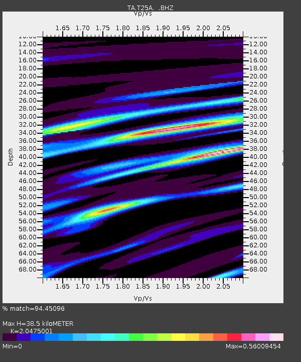
| Estimated Moho Depth: |
38.5 km |
| Estimated Crust Vp/Vs: |
2.05 |
| Assumed Crust Vp: |
6.316 km/s |
| Estimated Crust Vs: |
3.085 km/s |
| Estimated Crust Poisson's Ratio: |
0.34 |
|
| Radial Match: |
94.45096 % |
| Radial Bump: |
301 |
| Transverse Match: |
76.31113 % |
| Transverse Bump: |
400 |
| SOD ConfigId: |
319893 |
| Insert Time: |
2011-01-13 09:35:58.449 +0000 |
| GWidth: |
2.5 |
| Max Bumps: |
400 |
| Tol: |
0.001 |
|
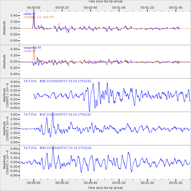
Signal To Noise
| Channel | StoN | STA | LTA |
| TA:T25A: :BHZ:20100909T07:39:34.375029Z | 3.2537725 | 1.887586E-7 | 5.8012233E-8 |
| TA:T25A: :BHN:20100909T07:39:34.375029Z | 1.8732054 | 9.055919E-8 | 4.8344507E-8 |
| TA:T25A: :BHE:20100909T07:39:34.375029Z | 0.91197455 | 6.4138064E-8 | 7.0328795E-8 |
| Arrivals |
| Ps | 6.5 SECOND |
| PpPs | 18 SECOND |
| PsPs/PpSs | 25 SECOND |


