You are here: Home > Network List > CN - Canadian National Seismograph Network Stations List
> Station INK INUVIK, NT > Earthquake Result Viewer
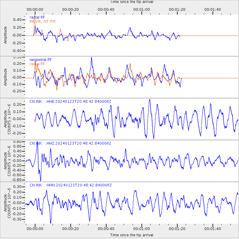
INK INUVIK, NT - Earthquake Result Viewer
*The percent match for this event was below the threshold and hence no stack was calculated.
| Earthquake location: |
Kyrgyzstan-Xinjiang Border Reg. |
| Earthquake latitude/longitude: |
41.1/78.6 |
| Earthquake time(UTC): |
2024/01/23 (023) 20:38:13 GMT |
| Earthquake Depth: |
10 km |
| Earthquake Magnitude: |
5.2 Mww |
| Earthquake Catalog/Contributor: |
NEIC PDE/us |
|
| Network: |
CN Canadian National Seismograph Network |
| Station: |
INK INUVIK, NT |
| Lat/Lon: |
68.31 N/133.53 W |
| Elevation: |
44 m |
|
| Distance: |
68.3 deg |
| Az: |
12.274 deg |
| Baz: |
334.413 deg |
| Ray Param: |
$rayparam |
*The percent match for this event was below the threshold and hence was not used in the summary stack. |
|
| Radial Match: |
56.552864 % |
| Radial Bump: |
400 |
| Transverse Match: |
57.567715 % |
| Transverse Bump: |
349 |
| SOD ConfigId: |
33437571 |
| Insert Time: |
2024-02-06 20:48:00.822 +0000 |
| GWidth: |
2.5 |
| Max Bumps: |
400 |
| Tol: |
0.001 |
|
Signal To Noise
| Channel | StoN | STA | LTA |
| CN:INK: :HHZ:20240123T20:48:42.840006Z | 4.2528534 | 4.2240774E-7 | 9.932338E-8 |
| CN:INK: :HHN:20240123T20:48:42.840006Z | 0.8805999 | 9.2270966E-8 | 1.0478193E-7 |
| CN:INK: :HHE:20240123T20:48:42.840006Z | 0.8758607 | 5.7912995E-8 | 6.612124E-8 |
| Arrivals |
| Ps | |
| PpPs | |
| PsPs/PpSs | |


