You are here: Home > Network List > TA - USArray Transportable Network (new EarthScope stations) Stations List
> Station Q24A Divide, CO, USA > Earthquake Result Viewer
Q24A Divide, CO, USA - Earthquake Result Viewer
| Earthquake location: |
Near Coast Of Central Chile |
| Earthquake latitude/longitude: |
-37.0/-73.4 |
| Earthquake time(UTC): |
2010/09/09 (252) 07:28:01 GMT |
| Earthquake Depth: |
16 km |
| Earthquake Magnitude: |
5.8 MB, 6.0 MS, 6.2 MW, 6.2 MW |
| Earthquake Catalog/Contributor: |
WHDF/NEIC |
|
| Network: |
TA USArray Transportable Network (new EarthScope stations) |
| Station: |
Q24A Divide, CO, USA |
| Lat/Lon: |
38.96 N/105.15 W |
| Elevation: |
2775 m |
|
| Distance: |
81.1 deg |
| Az: |
335.474 deg |
| Baz: |
154.781 deg |
| Ray Param: |
0.04782413 |
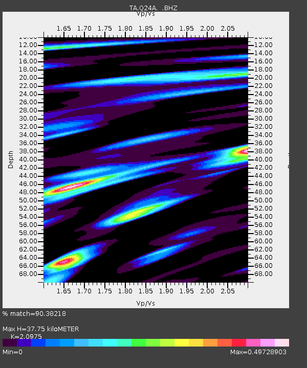
| Estimated Moho Depth: |
37.75 km |
| Estimated Crust Vp/Vs: |
2.10 |
| Assumed Crust Vp: |
6.159 km/s |
| Estimated Crust Vs: |
2.936 km/s |
| Estimated Crust Poisson's Ratio: |
0.35 |
|
| Radial Match: |
90.38218 % |
| Radial Bump: |
338 |
| Transverse Match: |
80.957115 % |
| Transverse Bump: |
400 |
| SOD ConfigId: |
319893 |
| Insert Time: |
2011-01-13 09:36:10.553 +0000 |
| GWidth: |
2.5 |
| Max Bumps: |
400 |
| Tol: |
0.001 |
|

Signal To Noise
| Channel | StoN | STA | LTA |
| TA:Q24A: :BHZ:20100909T07:39:44.57498Z | 3.668876 | 1.5768931E-7 | 4.2980275E-8 |
| TA:Q24A: :BHN:20100909T07:39:44.57498Z | 2.212216 | 9.1771454E-8 | 4.1483947E-8 |
| TA:Q24A: :BHE:20100909T07:39:44.57498Z | 1.029418 | 5.6506167E-8 | 5.4891373E-8 |
| Arrivals |
| Ps | 6.9 SECOND |
| PpPs | 19 SECOND |
| PsPs/PpSs | 25 SECOND |


