You are here: Home > Network List > UW - Pacific Northwest Regional Seismic Network Stations List
> Station UMAT Pilot Rock, OR, USA > Earthquake Result Viewer
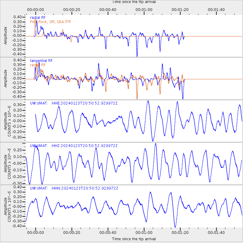
UMAT Pilot Rock, OR, USA - Earthquake Result Viewer
*The percent match for this event was below the threshold and hence no stack was calculated.
| Earthquake location: |
Kyrgyzstan-Xinjiang Border Reg. |
| Earthquake latitude/longitude: |
41.1/78.6 |
| Earthquake time(UTC): |
2024/01/23 (023) 20:38:13 GMT |
| Earthquake Depth: |
10 km |
| Earthquake Magnitude: |
5.2 Mww |
| Earthquake Catalog/Contributor: |
NEIC PDE/us |
|
| Network: |
UW Pacific Northwest Regional Seismic Network |
| Station: |
UMAT Pilot Rock, OR, USA |
| Lat/Lon: |
45.29 N/118.96 W |
| Elevation: |
1318 m |
|
| Distance: |
92.5 deg |
| Az: |
12.277 deg |
| Baz: |
346.848 deg |
| Ray Param: |
$rayparam |
*The percent match for this event was below the threshold and hence was not used in the summary stack. |
|
| Radial Match: |
50.556843 % |
| Radial Bump: |
395 |
| Transverse Match: |
42.715466 % |
| Transverse Bump: |
400 |
| SOD ConfigId: |
33437571 |
| Insert Time: |
2024-02-06 20:57:41.949 +0000 |
| GWidth: |
2.5 |
| Max Bumps: |
400 |
| Tol: |
0.001 |
|
Signal To Noise
| Channel | StoN | STA | LTA |
| UW:UMAT: :HHZ:20240123T20:50:52.929972Z | 2.1175408 | 2.1505974E-7 | 1.01561085E-7 |
| UW:UMAT: :HHN:20240123T20:50:52.929972Z | 0.851689 | 1.3400344E-7 | 1.5733848E-7 |
| UW:UMAT: :HHE:20240123T20:50:52.929972Z | 0.52555573 | 7.1122685E-8 | 1.3532853E-7 |
| Arrivals |
| Ps | |
| PpPs | |
| PsPs/PpSs | |


