You are here: Home > Network List > TA - USArray Transportable Network (new EarthScope stations) Stations List
> Station TUL1 Leonard, OK, USA > Earthquake Result Viewer
TUL1 Leonard, OK, USA - Earthquake Result Viewer
| Earthquake location: |
Near Coast Of Central Chile |
| Earthquake latitude/longitude: |
-37.0/-73.4 |
| Earthquake time(UTC): |
2010/09/09 (252) 07:28:01 GMT |
| Earthquake Depth: |
16 km |
| Earthquake Magnitude: |
5.8 MB, 6.0 MS, 6.2 MW, 6.2 MW |
| Earthquake Catalog/Contributor: |
WHDF/NEIC |
|
| Network: |
TA USArray Transportable Network (new EarthScope stations) |
| Station: |
TUL1 Leonard, OK, USA |
| Lat/Lon: |
35.91 N/95.79 W |
| Elevation: |
256 m |
|
| Distance: |
75.5 deg |
| Az: |
341.381 deg |
| Baz: |
161.656 deg |
| Ray Param: |
0.051620398 |
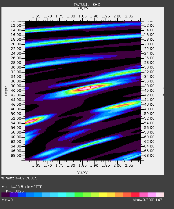
| Estimated Moho Depth: |
38.5 km |
| Estimated Crust Vp/Vs: |
1.88 |
| Assumed Crust Vp: |
6.498 km/s |
| Estimated Crust Vs: |
3.452 km/s |
| Estimated Crust Poisson's Ratio: |
0.30 |
|
| Radial Match: |
89.76315 % |
| Radial Bump: |
391 |
| Transverse Match: |
72.78876 % |
| Transverse Bump: |
400 |
| SOD ConfigId: |
319893 |
| Insert Time: |
2011-01-13 09:37:03.561 +0000 |
| GWidth: |
2.5 |
| Max Bumps: |
400 |
| Tol: |
0.001 |
|

Signal To Noise
| Channel | StoN | STA | LTA |
| TA:TUL1: :BHZ:20100909T07:39:13.750029Z | 4.1129413 | 2.9083918E-7 | 7.0713185E-8 |
| TA:TUL1: :BHN:20100909T07:39:13.750029Z | 1.9572735 | 1.391396E-7 | 7.1088486E-8 |
| TA:TUL1: :BHE:20100909T07:39:13.750029Z | 1.3894573 | 8.953327E-8 | 6.4437586E-8 |
| Arrivals |
| Ps | 5.4 SECOND |
| PpPs | 17 SECOND |
| PsPs/PpSs | 22 SECOND |


