You are here: Home > Network List > TA - USArray Transportable Network (new EarthScope stations) Stations List
> Station R26A Arlington, CO, USA > Earthquake Result Viewer
R26A Arlington, CO, USA - Earthquake Result Viewer

| Earthquake location: |
Near Coast Of Central Chile |
| Earthquake latitude/longitude: |
-37.0/-73.4 |
| Earthquake time(UTC): |
2010/09/09 (252) 07:28:01 GMT |
| Earthquake Depth: |
16 km |
| Earthquake Magnitude: |
5.8 MB, 6.0 MS, 6.2 MW, 6.2 MW |
| Earthquake Catalog/Contributor: |
WHDF/NEIC |
|
| Network: |
TA USArray Transportable Network (new EarthScope stations) |
| Station: |
R26A Arlington, CO, USA |
| Lat/Lon: |
38.30 N/103.45 W |
| Elevation: |
1304 m |
|
| Distance: |
79.9 deg |
| Az: |
336.423 deg |
| Baz: |
155.996 deg |
| Ray Param: |
0.048614845 |
| Estimated Moho Depth: |
45.5 km |
| Estimated Crust Vp/Vs: |
1.91 |
| Assumed Crust Vp: |
6.242 km/s |
| Estimated Crust Vs: |
3.264 km/s |
| Estimated Crust Poisson's Ratio: |
0.31 |
|
| Radial Match: |
86.9779 % |
| Radial Bump: |
400 |
| Transverse Match: |
77.33272 % |
| Transverse Bump: |
399 |
| SOD ConfigId: |
319893 |
| Insert Time: |
2011-01-13 09:37:39.385 +0000 |
| GWidth: |
2.5 |
| Max Bumps: |
400 |
| Tol: |
0.001 |
|
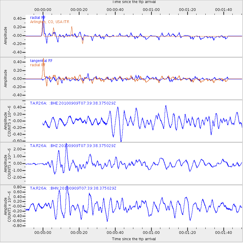
Signal To Noise
| Channel | StoN | STA | LTA |
| TA:R26A: :BHZ:20100909T07:39:38.375029Z | 3.7938683 | 1.7616802E-7 | 4.643493E-8 |
| TA:R26A: :BHN:20100909T07:39:38.375029Z | 0.9302086 | 8.393258E-8 | 9.0229854E-8 |
| TA:R26A: :BHE:20100909T07:39:38.375029Z | 0.67110884 | 5.8418436E-8 | 8.704764E-8 |
| Arrivals |
| Ps | 6.8 SECOND |
| PpPs | 21 SECOND |
| PsPs/PpSs | 28 SECOND |


