You are here: Home > Network List > TA - USArray Transportable Network (new EarthScope stations) Stations List
> Station V28A Channing, TX, USA > Earthquake Result Viewer
V28A Channing, TX, USA - Earthquake Result Viewer

| Earthquake location: |
Near Coast Of Central Chile |
| Earthquake latitude/longitude: |
-37.0/-73.4 |
| Earthquake time(UTC): |
2010/09/09 (252) 07:28:01 GMT |
| Earthquake Depth: |
16 km |
| Earthquake Magnitude: |
5.8 MB, 6.0 MS, 6.2 MW, 6.2 MW |
| Earthquake Catalog/Contributor: |
WHDF/NEIC |
|
| Network: |
TA USArray Transportable Network (new EarthScope stations) |
| Station: |
V28A Channing, TX, USA |
| Lat/Lon: |
35.75 N/102.22 W |
| Elevation: |
1163 m |
|
| Distance: |
77.2 deg |
| Az: |
336.296 deg |
| Baz: |
156.704 deg |
| Ray Param: |
0.050470617 |
| Estimated Moho Depth: |
21.5 km |
| Estimated Crust Vp/Vs: |
2.04 |
| Assumed Crust Vp: |
6.242 km/s |
| Estimated Crust Vs: |
3.067 km/s |
| Estimated Crust Poisson's Ratio: |
0.34 |
|
| Radial Match: |
93.77129 % |
| Radial Bump: |
400 |
| Transverse Match: |
85.17333 % |
| Transverse Bump: |
400 |
| SOD ConfigId: |
319893 |
| Insert Time: |
2011-01-13 09:38:10.291 +0000 |
| GWidth: |
2.5 |
| Max Bumps: |
400 |
| Tol: |
0.001 |
|
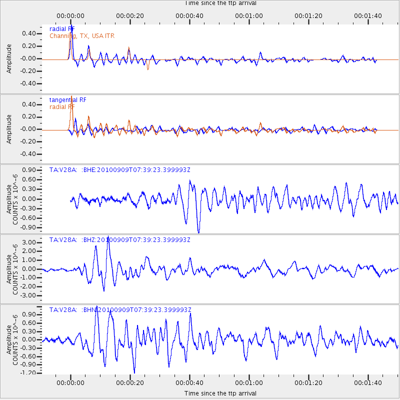
Signal To Noise
| Channel | StoN | STA | LTA |
| TA:V28A: :BHZ:20100909T07:39:23.399993Z | 3.517762 | 2.463663E-7 | 7.003496E-8 |
| TA:V28A: :BHN:20100909T07:39:23.399993Z | 1.4744301 | 1.5603902E-7 | 1.0583006E-7 |
| TA:V28A: :BHE:20100909T07:39:23.399993Z | 1.0725433 | 1.0721992E-7 | 9.996792E-8 |
| Arrivals |
| Ps | 3.7 SECOND |
| PpPs | 10 SECOND |
| PsPs/PpSs | 14 SECOND |


