You are here: Home > Network List > TA - USArray Transportable Network (new EarthScope stations) Stations List
> Station 128A Castleberry Farm, Seminole, TX, USA > Earthquake Result Viewer
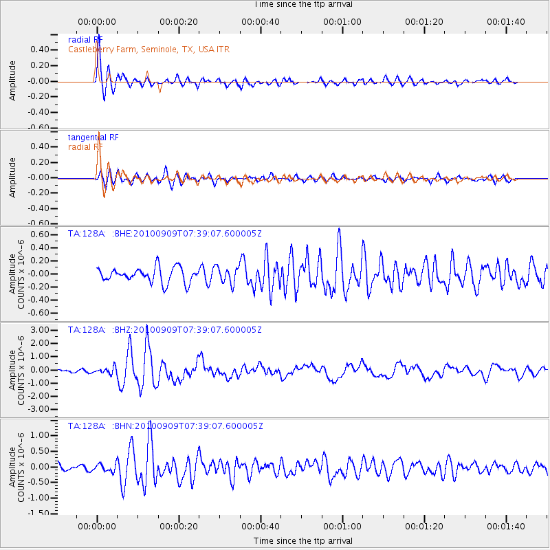
128A Castleberry Farm, Seminole, TX, USA - Earthquake Result Viewer
| Earthquake location: |
Near Coast Of Central Chile |
| Earthquake latitude/longitude: |
-37.0/-73.4 |
| Earthquake time(UTC): |
2010/09/09 (252) 07:28:01 GMT |
| Earthquake Depth: |
16 km |
| Earthquake Magnitude: |
5.8 MB, 6.0 MS, 6.2 MW, 6.2 MW |
| Earthquake Catalog/Contributor: |
WHDF/NEIC |
|
| Network: |
TA USArray Transportable Network (new EarthScope stations) |
| Station: |
128A Castleberry Farm, Seminole, TX, USA |
| Lat/Lon: |
32.62 N/102.49 W |
| Elevation: |
966 m |
|
| Distance: |
74.4 deg |
| Az: |
334.806 deg |
| Baz: |
156.193 deg |
| Ray Param: |
0.052328844 |
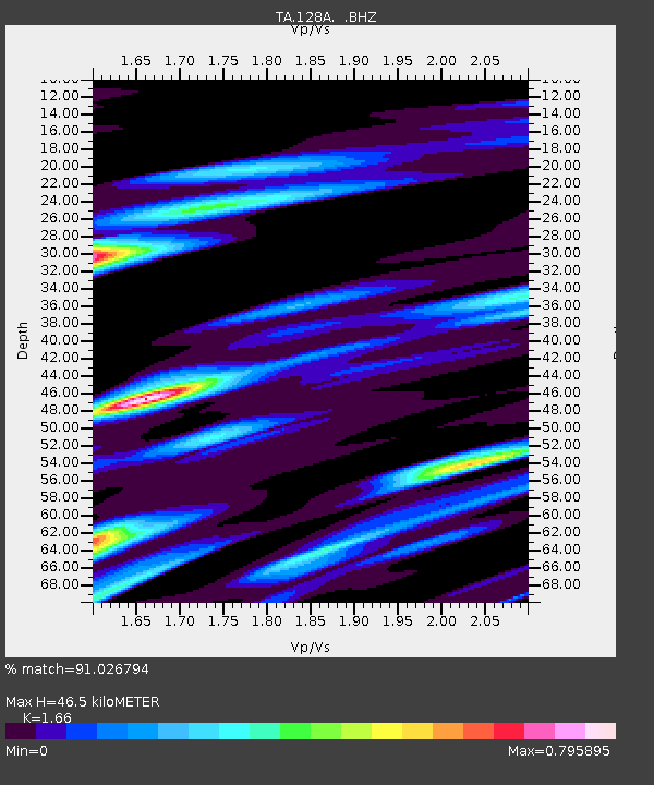
| Estimated Moho Depth: |
46.5 km |
| Estimated Crust Vp/Vs: |
1.66 |
| Assumed Crust Vp: |
6.129 km/s |
| Estimated Crust Vs: |
3.692 km/s |
| Estimated Crust Poisson's Ratio: |
0.22 |
|
| Radial Match: |
91.026794 % |
| Radial Bump: |
400 |
| Transverse Match: |
74.47497 % |
| Transverse Bump: |
400 |
| SOD ConfigId: |
319893 |
| Insert Time: |
2011-01-13 09:38:56.292 +0000 |
| GWidth: |
2.5 |
| Max Bumps: |
400 |
| Tol: |
0.001 |
|
Signal To Noise
| Channel | StoN | STA | LTA |
| TA:128A: :BHZ:20100909T07:39:07.600005Z | 1.998824 | 2.3862637E-7 | 1.1938339E-7 |
| TA:128A: :BHN:20100909T07:39:07.600005Z | 1.1225655 | 1.2067179E-7 | 1.07496426E-7 |
| TA:128A: :BHE:20100909T07:39:07.600005Z | 1.1049052 | 1.2518619E-7 | 1.1330039E-7 |
| Arrivals |
| Ps | 5.2 SECOND |
| PpPs | 20 SECOND |
| PsPs/PpSs | 25 SECOND |


