You are here: Home > Network List > TA - USArray Transportable Network (new EarthScope stations) Stations List
> Station 228A UT Block 9, Goldsmith, TX, USA > Earthquake Result Viewer
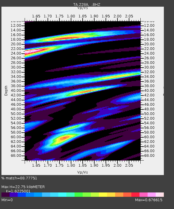
228A UT Block 9, Goldsmith, TX, USA - Earthquake Result Viewer
| Earthquake location: |
Near Coast Of Central Chile |
| Earthquake latitude/longitude: |
-37.0/-73.4 |
| Earthquake time(UTC): |
2010/09/09 (252) 07:28:01 GMT |
| Earthquake Depth: |
16 km |
| Earthquake Magnitude: |
5.8 MB, 6.0 MS, 6.2 MW, 6.2 MW |
| Earthquake Catalog/Contributor: |
WHDF/NEIC |
|
| Network: |
TA USArray Transportable Network (new EarthScope stations) |
| Station: |
228A UT Block 9, Goldsmith, TX, USA |
| Lat/Lon: |
32.12 N/102.59 W |
| Elevation: |
954 m |
|
| Distance: |
74.0 deg |
| Az: |
334.509 deg |
| Baz: |
156.055 deg |
| Ray Param: |
0.052612707 |
| Estimated Moho Depth: |
22.75 km |
| Estimated Crust Vp/Vs: |
1.62 |
| Assumed Crust Vp: |
6.129 km/s |
| Estimated Crust Vs: |
3.777 km/s |
| Estimated Crust Poisson's Ratio: |
0.19 |
|
| Radial Match: |
88.77751 % |
| Radial Bump: |
400 |
| Transverse Match: |
82.12464 % |
| Transverse Bump: |
400 |
| SOD ConfigId: |
319893 |
| Insert Time: |
2011-01-13 09:39:12.144 +0000 |
| GWidth: |
2.5 |
| Max Bumps: |
400 |
| Tol: |
0.001 |
|

Signal To Noise
| Channel | StoN | STA | LTA |
| TA:228A: :BHZ:20100909T07:39:05.149993Z | 4.394876 | 3.4722498E-7 | 7.9006774E-8 |
| TA:228A: :BHN:20100909T07:39:05.149993Z | 1.5849997 | 1.6917015E-7 | 1.06731974E-7 |
| TA:228A: :BHE:20100909T07:39:05.149993Z | 1.8123512 | 1.3827902E-7 | 7.6298136E-8 |
| Arrivals |
| Ps | 2.4 SECOND |
| PpPs | 9.4 SECOND |
| PsPs/PpSs | 12 SECOND |


