You are here: Home > Network List > TA - USArray Transportable Network (new EarthScope stations) Stations List
> Station 231A Bronte, TX, USA > Earthquake Result Viewer
231A Bronte, TX, USA - Earthquake Result Viewer

| Earthquake location: |
Near Coast Of Central Chile |
| Earthquake latitude/longitude: |
-37.0/-73.4 |
| Earthquake time(UTC): |
2010/09/09 (252) 07:28:01 GMT |
| Earthquake Depth: |
16 km |
| Earthquake Magnitude: |
5.8 MB, 6.0 MS, 6.2 MW, 6.2 MW |
| Earthquake Catalog/Contributor: |
WHDF/NEIC |
|
| Network: |
TA USArray Transportable Network (new EarthScope stations) |
| Station: |
231A Bronte, TX, USA |
| Lat/Lon: |
31.94 N/100.32 W |
| Elevation: |
574 m |
|
| Distance: |
73.1 deg |
| Az: |
336.288 deg |
| Baz: |
157.76 deg |
| Ray Param: |
0.053227987 |
| Estimated Moho Depth: |
60.75 km |
| Estimated Crust Vp/Vs: |
1.94 |
| Assumed Crust Vp: |
6.38 km/s |
| Estimated Crust Vs: |
3.285 km/s |
| Estimated Crust Poisson's Ratio: |
0.32 |
|
| Radial Match: |
94.62751 % |
| Radial Bump: |
225 |
| Transverse Match: |
75.79095 % |
| Transverse Bump: |
375 |
| SOD ConfigId: |
319893 |
| Insert Time: |
2011-01-13 09:40:21.543 +0000 |
| GWidth: |
2.5 |
| Max Bumps: |
400 |
| Tol: |
0.001 |
|
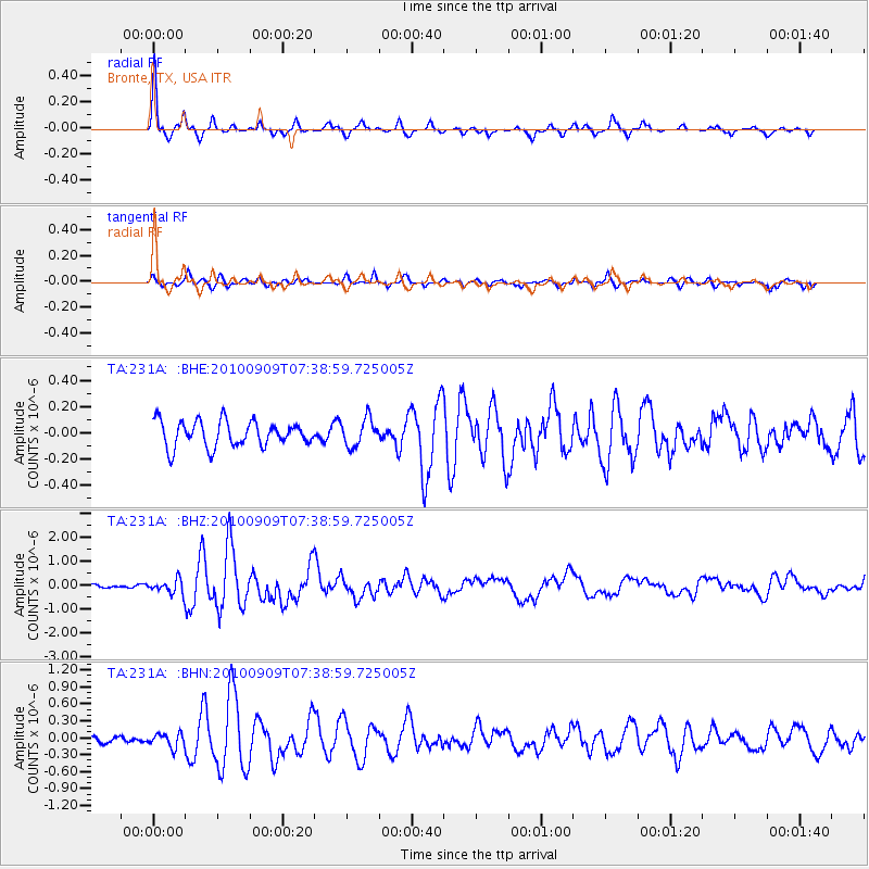
Signal To Noise
| Channel | StoN | STA | LTA |
| TA:231A: :BHZ:20100909T07:38:59.725005Z | 4.935269 | 2.9103614E-7 | 5.8970674E-8 |
| TA:231A: :BHN:20100909T07:38:59.725005Z | 1.9523536 | 1.2172602E-7 | 6.234835E-8 |
| TA:231A: :BHE:20100909T07:38:59.725005Z | 1.0789723 | 1.040375E-7 | 9.6422774E-8 |
| Arrivals |
| Ps | 9.3 SECOND |
| PpPs | 27 SECOND |
| PsPs/PpSs | 36 SECOND |


