You are here: Home > Network List > TA - USArray Transportable Network (new EarthScope stations) Stations List
> Station Y32A R-V Farms, Vernon, TX, USA > Earthquake Result Viewer
Y32A R-V Farms, Vernon, TX, USA - Earthquake Result Viewer
| Earthquake location: |
Near Coast Of Central Chile |
| Earthquake latitude/longitude: |
-37.0/-73.4 |
| Earthquake time(UTC): |
2010/09/09 (252) 07:28:01 GMT |
| Earthquake Depth: |
16 km |
| Earthquake Magnitude: |
5.8 MB, 6.0 MS, 6.2 MW, 6.2 MW |
| Earthquake Catalog/Contributor: |
WHDF/NEIC |
|
| Network: |
TA USArray Transportable Network (new EarthScope stations) |
| Station: |
Y32A R-V Farms, Vernon, TX, USA |
| Lat/Lon: |
34.00 N/99.44 W |
| Elevation: |
412 m |
|
| Distance: |
74.7 deg |
| Az: |
337.795 deg |
| Baz: |
158.652 deg |
| Ray Param: |
0.052130993 |
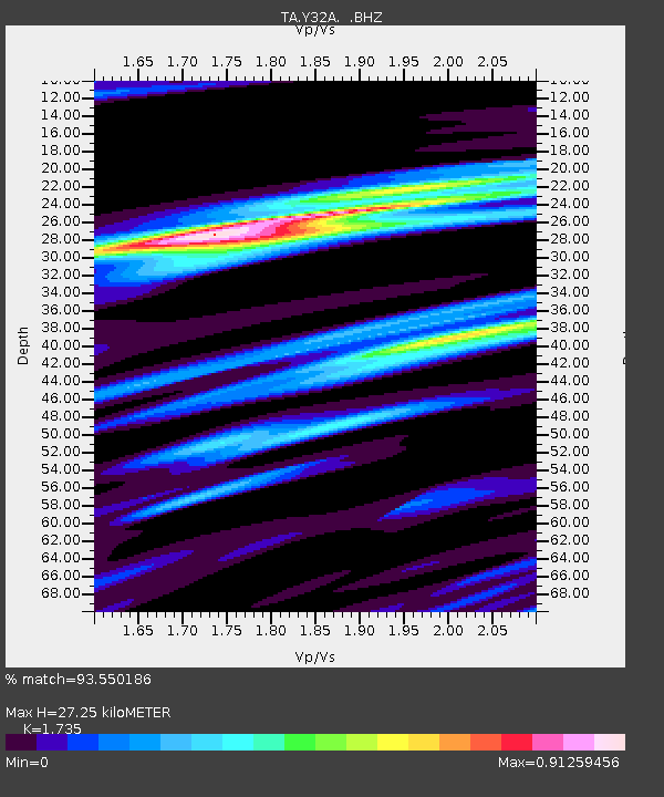
| Estimated Moho Depth: |
27.25 km |
| Estimated Crust Vp/Vs: |
1.74 |
| Assumed Crust Vp: |
6.315 km/s |
| Estimated Crust Vs: |
3.64 km/s |
| Estimated Crust Poisson's Ratio: |
0.25 |
|
| Radial Match: |
93.550186 % |
| Radial Bump: |
381 |
| Transverse Match: |
70.19298 % |
| Transverse Bump: |
400 |
| SOD ConfigId: |
319893 |
| Insert Time: |
2011-01-13 09:41:45.189 +0000 |
| GWidth: |
2.5 |
| Max Bumps: |
400 |
| Tol: |
0.001 |
|

Signal To Noise
| Channel | StoN | STA | LTA |
| TA:Y32A: :BHZ:20100909T07:39:09.300017Z | 3.7250457 | 2.406645E-7 | 6.460713E-8 |
| TA:Y32A: :BHN:20100909T07:39:09.300017Z | 1.511099 | 1.3475393E-7 | 8.917611E-8 |
| TA:Y32A: :BHE:20100909T07:39:09.300017Z | 1.3187981 | 1.2492467E-7 | 9.472615E-8 |
| Arrivals |
| Ps | 3.3 SECOND |
| PpPs | 11 SECOND |
| PsPs/PpSs | 15 SECOND |


