You are here: Home > Network List > CC - Cascade Chain Volcano Monitoring Stations List
> Station BRSP Barrett Spur > Earthquake Result Viewer
BRSP Barrett Spur - Earthquake Result Viewer
| Earthquake location: |
Guatemala |
| Earthquake latitude/longitude: |
14.1/-90.5 |
| Earthquake time(UTC): |
2024/01/27 (027) 05:52:49 GMT |
| Earthquake Depth: |
108 km |
| Earthquake Magnitude: |
6.1 Mww |
| Earthquake Catalog/Contributor: |
NEIC PDE/us |
|
| Network: |
CC Cascade Chain Volcano Monitoring |
| Station: |
BRSP Barrett Spur |
| Lat/Lon: |
45.40 N/121.71 W |
| Elevation: |
2080 m |
|
| Distance: |
40.8 deg |
| Az: |
326.078 deg |
| Baz: |
129.78 deg |
| Ray Param: |
0.07379132 |
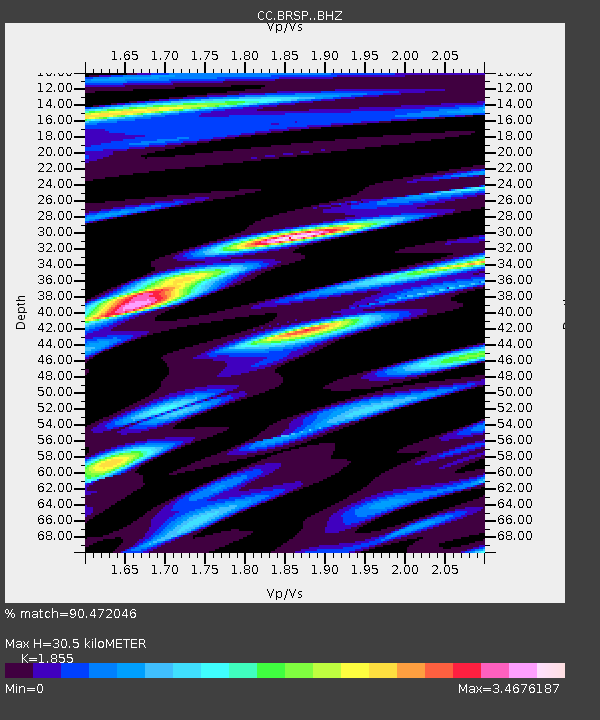
| Estimated Moho Depth: |
30.5 km |
| Estimated Crust Vp/Vs: |
1.86 |
| Assumed Crust Vp: |
6.597 km/s |
| Estimated Crust Vs: |
3.557 km/s |
| Estimated Crust Poisson's Ratio: |
0.30 |
|
| Radial Match: |
90.472046 % |
| Radial Bump: |
352 |
| Transverse Match: |
93.09641 % |
| Transverse Bump: |
334 |
| SOD ConfigId: |
33437571 |
| Insert Time: |
2024-02-10 06:02:05.893 +0000 |
| GWidth: |
2.5 |
| Max Bumps: |
400 |
| Tol: |
0.001 |
|

Signal To Noise
| Channel | StoN | STA | LTA |
| CC:BRSP: :BHZ:20240127T05:59:50.380003Z | 21.856915 | 8.937227E-6 | 4.0889702E-7 |
| CC:BRSP: :BHN:20240127T05:59:50.380003Z | 10.57954 | 7.386388E-6 | 6.981766E-7 |
| CC:BRSP: :BHE:20240127T05:59:50.380003Z | 6.94018 | 4.1552576E-6 | 5.987248E-7 |
| Arrivals |
| Ps | 4.2 SECOND |
| PpPs | 12 SECOND |
| PsPs/PpSs | 17 SECOND |


