You are here: Home > Network List > TX - Texas Seismological Network Stations List
> Station WTFS Witchita Falls > Earthquake Result Viewer
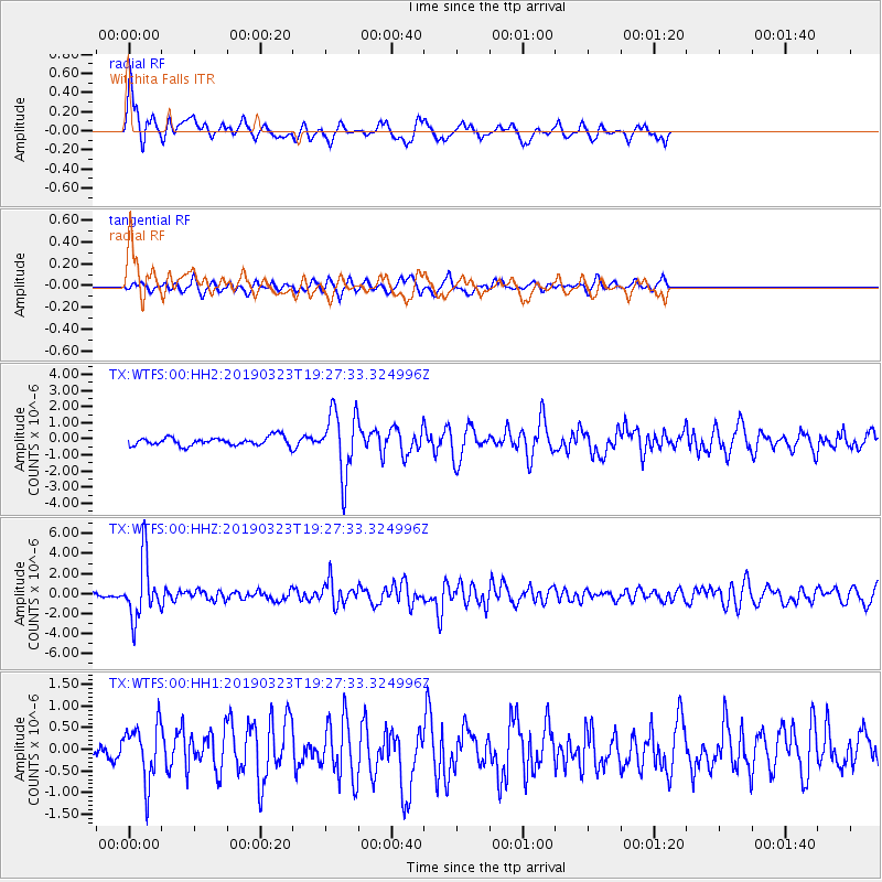
WTFS Witchita Falls - Earthquake Result Viewer

| Earthquake location: |
Colombia |
| Earthquake latitude/longitude: |
4.6/-76.3 |
| Earthquake time(UTC): |
2019/03/23 (082) 19:21:16 GMT |
| Earthquake Depth: |
113 km |
| Earthquake Magnitude: |
6.1 Mww |
| Earthquake Catalog/Contributor: |
NEIC PDE/us |
|
| Network: |
TX Texas Seismological Network |
| Station: |
WTFS Witchita Falls |
| Lat/Lon: |
33.77 N/98.46 W |
| Elevation: |
277 m |
|
| Distance: |
35.6 deg |
| Az: |
327.334 deg |
| Baz: |
139.766 deg |
| Ray Param: |
0.07673501 |
| Estimated Moho Depth: |
10.0 km |
| Estimated Crust Vp/Vs: |
1.80 |
| Assumed Crust Vp: |
6.426 km/s |
| Estimated Crust Vs: |
3.575 km/s |
| Estimated Crust Poisson's Ratio: |
0.28 |
|
| Radial Match: |
80.621414 % |
| Radial Bump: |
368 |
| Transverse Match: |
59.548462 % |
| Transverse Bump: |
383 |
| SOD ConfigId: |
3338192 |
| Insert Time: |
2019-04-06 19:48:41.082 +0000 |
| GWidth: |
2.5 |
| Max Bumps: |
400 |
| Tol: |
0.001 |
|
Signal To Noise
| Channel | StoN | STA | LTA |
| TX:WTFS:00:HHZ:20190323T19:27:33.324996Z | 12.263097 | 2.88655E-6 | 2.3538507E-7 |
| TX:WTFS:00:HH1:20190323T19:27:33.324996Z | 2.243728 | 6.691318E-7 | 2.9822323E-7 |
| TX:WTFS:00:HH2:20190323T19:27:33.324996Z | 7.2756495 | 1.9542204E-6 | 2.6859738E-7 |
| Arrivals |
| Ps | 1.3 SECOND |
| PpPs | 4.0 SECOND |
| PsPs/PpSs | 5.4 SECOND |


