You are here: Home > Network List > TA - USArray Transportable Network (new EarthScope stations) Stations List
> Station P29A Atwood, KS, USA > Earthquake Result Viewer
P29A Atwood, KS, USA - Earthquake Result Viewer
| Earthquake location: |
Near Coast Of Central Chile |
| Earthquake latitude/longitude: |
-37.0/-73.4 |
| Earthquake time(UTC): |
2010/09/09 (252) 07:28:01 GMT |
| Earthquake Depth: |
16 km |
| Earthquake Magnitude: |
5.8 MB, 6.0 MS, 6.2 MW, 6.2 MW |
| Earthquake Catalog/Contributor: |
WHDF/NEIC |
|
| Network: |
TA USArray Transportable Network (new EarthScope stations) |
| Station: |
P29A Atwood, KS, USA |
| Lat/Lon: |
39.60 N/100.93 W |
| Elevation: |
929 m |
|
| Distance: |
80.4 deg |
| Az: |
338.771 deg |
| Baz: |
157.973 deg |
| Ray Param: |
0.048321594 |
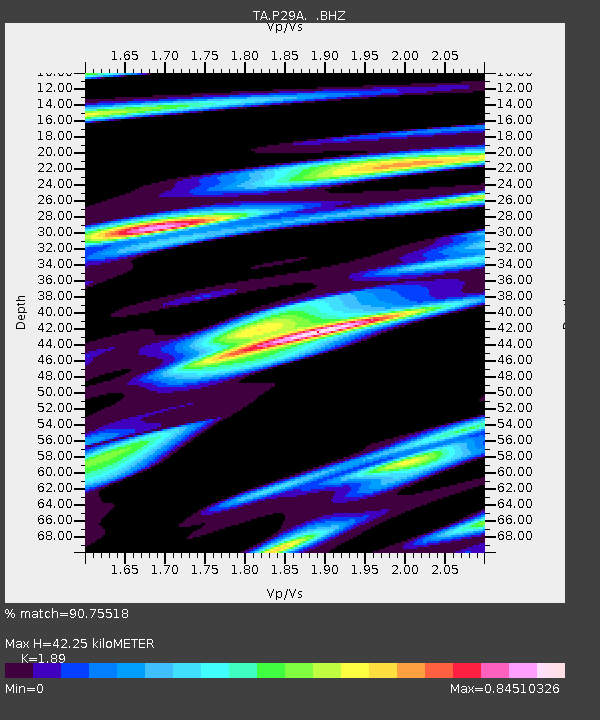
| Estimated Moho Depth: |
42.25 km |
| Estimated Crust Vp/Vs: |
1.89 |
| Assumed Crust Vp: |
6.483 km/s |
| Estimated Crust Vs: |
3.43 km/s |
| Estimated Crust Poisson's Ratio: |
0.31 |
|
| Radial Match: |
90.75518 % |
| Radial Bump: |
400 |
| Transverse Match: |
71.061966 % |
| Transverse Bump: |
400 |
| SOD ConfigId: |
319893 |
| Insert Time: |
2011-01-13 09:43:02.141 +0000 |
| GWidth: |
2.5 |
| Max Bumps: |
400 |
| Tol: |
0.001 |
|

Signal To Noise
| Channel | StoN | STA | LTA |
| TA:P29A: :BHZ:20100909T07:39:40.675017Z | 2.8854709 | 2.3801563E-7 | 8.2487624E-8 |
| TA:P29A: :BHN:20100909T07:39:40.675017Z | 1.1516058 | 1.455443E-7 | 1.263838E-7 |
| TA:P29A: :BHE:20100909T07:39:40.675017Z | 0.7262306 | 1.3161424E-7 | 1.8122927E-7 |
| Arrivals |
| Ps | 6.0 SECOND |
| PpPs | 18 SECOND |
| PsPs/PpSs | 24 SECOND |


