You are here: Home > Network List > CI - Caltech Regional Seismic Network Stations List
> Station FMP Fort MacArthur Park, Pt. Fermin San Pedro, CA, USA > Earthquake Result Viewer
FMP Fort MacArthur Park, Pt. Fermin San Pedro, CA, USA - Earthquake Result Viewer
*The percent match for this event was below the threshold and hence no stack was calculated.
| Earthquake location: |
Guatemala |
| Earthquake latitude/longitude: |
14.1/-90.5 |
| Earthquake time(UTC): |
2024/01/27 (027) 05:52:49 GMT |
| Earthquake Depth: |
108 km |
| Earthquake Magnitude: |
6.1 Mww |
| Earthquake Catalog/Contributor: |
NEIC PDE/us |
|
| Network: |
CI Caltech Regional Seismic Network |
| Station: |
FMP Fort MacArthur Park, Pt. Fermin San Pedro, CA, USA |
| Lat/Lon: |
33.71 N/118.29 W |
| Elevation: |
89 m |
|
| Distance: |
31.9 deg |
| Az: |
312.609 deg |
| Baz: |
121.057 deg |
| Ray Param: |
$rayparam |
*The percent match for this event was below the threshold and hence was not used in the summary stack. |
|
| Radial Match: |
75.89987 % |
| Radial Bump: |
400 |
| Transverse Match: |
85.11744 % |
| Transverse Bump: |
400 |
| SOD ConfigId: |
33437571 |
| Insert Time: |
2024-02-10 06:03:56.603 +0000 |
| GWidth: |
2.5 |
| Max Bumps: |
400 |
| Tol: |
0.001 |
|
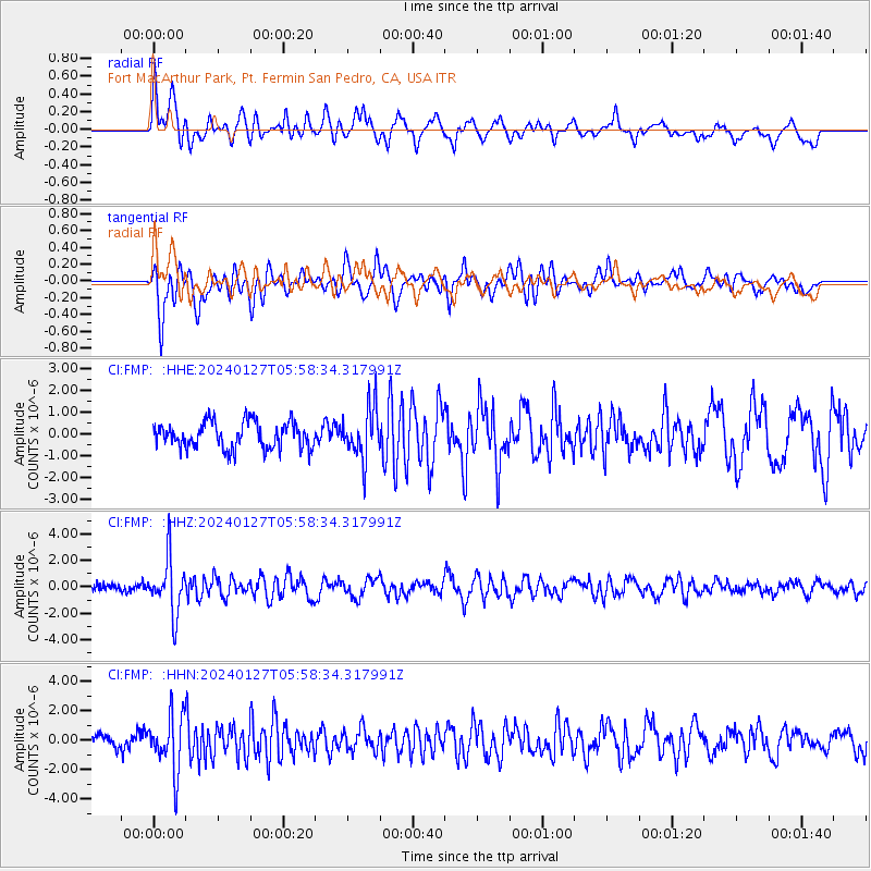
Signal To Noise
| Channel | StoN | STA | LTA |
| CI:FMP: :HHZ:20240127T05:58:34.317991Z | 5.8662786 | 2.0790494E-6 | 3.5440686E-7 |
| CI:FMP: :HHN:20240127T05:58:34.317991Z | 2.8105261 | 1.895531E-6 | 6.7443995E-7 |
| CI:FMP: :HHE:20240127T05:58:34.317991Z | 1.9482379 | 1.1772255E-6 | 6.042514E-7 |
| Arrivals |
| Ps | |
| PpPs | |
| PsPs/PpSs | |


