You are here: Home > Network List > TA - USArray Transportable Network (new EarthScope stations) Stations List
> Station O30A M W Ranch, Wilsonville, NE, USA > Earthquake Result Viewer
O30A M W Ranch, Wilsonville, NE, USA - Earthquake Result Viewer
| Earthquake location: |
Near Coast Of Central Chile |
| Earthquake latitude/longitude: |
-37.0/-73.4 |
| Earthquake time(UTC): |
2010/09/09 (252) 07:28:01 GMT |
| Earthquake Depth: |
16 km |
| Earthquake Magnitude: |
5.8 MB, 6.0 MS, 6.2 MW, 6.2 MW |
| Earthquake Catalog/Contributor: |
WHDF/NEIC |
|
| Network: |
TA USArray Transportable Network (new EarthScope stations) |
| Station: |
O30A M W Ranch, Wilsonville, NE, USA |
| Lat/Lon: |
40.18 N/100.06 W |
| Elevation: |
751 m |
|
| Distance: |
80.6 deg |
| Az: |
339.621 deg |
| Baz: |
158.672 deg |
| Ray Param: |
0.04812638 |
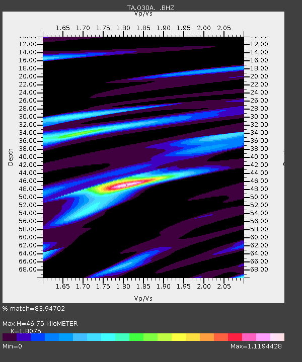
| Estimated Moho Depth: |
46.75 km |
| Estimated Crust Vp/Vs: |
1.81 |
| Assumed Crust Vp: |
6.483 km/s |
| Estimated Crust Vs: |
3.587 km/s |
| Estimated Crust Poisson's Ratio: |
0.28 |
|
| Radial Match: |
83.94702 % |
| Radial Bump: |
400 |
| Transverse Match: |
63.493763 % |
| Transverse Bump: |
400 |
| SOD ConfigId: |
319893 |
| Insert Time: |
2011-01-13 09:43:53.457 +0000 |
| GWidth: |
2.5 |
| Max Bumps: |
400 |
| Tol: |
0.001 |
|

Signal To Noise
| Channel | StoN | STA | LTA |
| TA:O30A: :BHZ:20100909T07:39:42.225005Z | 2.7517142 | 2.3756661E-7 | 8.633404E-8 |
| TA:O30A: :BHN:20100909T07:39:42.225005Z | 0.7580226 | 1.260625E-7 | 1.663044E-7 |
| TA:O30A: :BHE:20100909T07:39:42.225005Z | 1.8288934 | 2.7323344E-7 | 1.4939823E-7 |
| Arrivals |
| Ps | 6.0 SECOND |
| PpPs | 20 SECOND |
| PsPs/PpSs | 26 SECOND |


