You are here: Home > Network List > TX - Texas Seismological Network Stations List
> Station MB05 Klondike > Earthquake Result Viewer
MB05 Klondike - Earthquake Result Viewer
| Earthquake location: |
Colombia |
| Earthquake latitude/longitude: |
4.6/-76.3 |
| Earthquake time(UTC): |
2019/03/23 (082) 19:21:16 GMT |
| Earthquake Depth: |
113 km |
| Earthquake Magnitude: |
6.1 Mww |
| Earthquake Catalog/Contributor: |
NEIC PDE/us |
|
| Network: |
TX Texas Seismological Network |
| Station: |
MB05 Klondike |
| Lat/Lon: |
32.63 N/101.86 W |
| Elevation: |
882 m |
|
| Distance: |
36.8 deg |
| Az: |
322.5 deg |
| Baz: |
134.014 deg |
| Ray Param: |
0.0761313 |
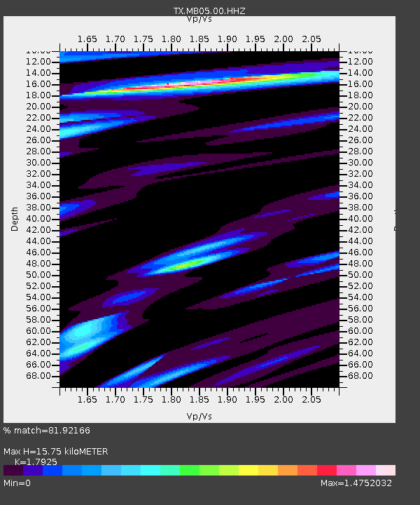
| Estimated Moho Depth: |
15.75 km |
| Estimated Crust Vp/Vs: |
1.79 |
| Assumed Crust Vp: |
6.426 km/s |
| Estimated Crust Vs: |
3.585 km/s |
| Estimated Crust Poisson's Ratio: |
0.27 |
|
| Radial Match: |
81.92166 % |
| Radial Bump: |
400 |
| Transverse Match: |
68.72527 % |
| Transverse Bump: |
400 |
| SOD ConfigId: |
3338192 |
| Insert Time: |
2019-04-06 19:49:02.121 +0000 |
| GWidth: |
2.5 |
| Max Bumps: |
400 |
| Tol: |
0.001 |
|

Signal To Noise
| Channel | StoN | STA | LTA |
| TX:MB05:00:HHZ:20190323T19:27:42.810012Z | 15.829753 | 1.7693554E-6 | 1.1177404E-7 |
| TX:MB05:00:HH1:20190323T19:27:42.810012Z | 1.3997555 | 2.8462946E-7 | 2.0334228E-7 |
| TX:MB05:00:HH2:20190323T19:27:42.810012Z | 6.321182 | 8.2299516E-7 | 1.3019641E-7 |
| Arrivals |
| Ps | 2.1 SECOND |
| PpPs | 6.4 SECOND |
| PsPs/PpSs | 8.5 SECOND |


