You are here: Home > Network List > IM - International Miscellaneous Stations Stations List
> Station NV31 NVAR Array Site 31, Mina, NV, USA > Earthquake Result Viewer
NV31 NVAR Array Site 31, Mina, NV, USA - Earthquake Result Viewer
| Earthquake location: |
Guatemala |
| Earthquake latitude/longitude: |
14.1/-90.5 |
| Earthquake time(UTC): |
2024/01/27 (027) 05:52:49 GMT |
| Earthquake Depth: |
108 km |
| Earthquake Magnitude: |
6.1 Mww |
| Earthquake Catalog/Contributor: |
NEIC PDE/us |
|
| Network: |
IM International Miscellaneous Stations |
| Station: |
NV31 NVAR Array Site 31, Mina, NV, USA |
| Lat/Lon: |
38.43 N/118.16 W |
| Elevation: |
1509 m |
|
| Distance: |
34.4 deg |
| Az: |
319.86 deg |
| Baz: |
127.215 deg |
| Ray Param: |
0.07742037 |
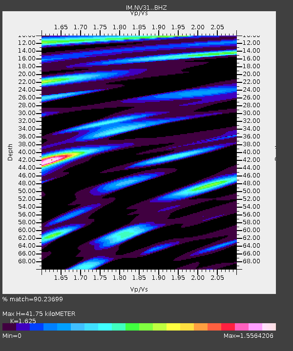
| Estimated Moho Depth: |
41.75 km |
| Estimated Crust Vp/Vs: |
1.62 |
| Assumed Crust Vp: |
6.279 km/s |
| Estimated Crust Vs: |
3.864 km/s |
| Estimated Crust Poisson's Ratio: |
0.20 |
|
| Radial Match: |
90.23699 % |
| Radial Bump: |
400 |
| Transverse Match: |
85.621826 % |
| Transverse Bump: |
400 |
| SOD ConfigId: |
33437571 |
| Insert Time: |
2024-02-10 06:09:33.448 +0000 |
| GWidth: |
2.5 |
| Max Bumps: |
400 |
| Tol: |
0.001 |
|

Signal To Noise
| Channel | StoN | STA | LTA |
| IM:NV31: :BHZ:20240127T05:58:56.475004Z | 20.854008 | 3.2146231E-6 | 1.5414894E-7 |
| IM:NV31: :BHN:20240127T05:58:56.475004Z | 3.7331917 | 6.430611E-7 | 1.7225506E-7 |
| IM:NV31: :BHE:20240127T05:58:56.475004Z | 9.03602 | 1.4732566E-6 | 1.6304264E-7 |
| Arrivals |
| Ps | 4.5 SECOND |
| PpPs | 16 SECOND |
| PsPs/PpSs | 21 SECOND |


