You are here: Home > Network List > US - United States National Seismic Network Stations List
> Station DGMT Dagmar, Montana, USA > Earthquake Result Viewer
DGMT Dagmar, Montana, USA - Earthquake Result Viewer
*The percent match for this event was below the threshold and hence no stack was calculated.
| Earthquake location: |
Colombia |
| Earthquake latitude/longitude: |
4.6/-76.3 |
| Earthquake time(UTC): |
2019/03/23 (082) 19:21:16 GMT |
| Earthquake Depth: |
113 km |
| Earthquake Magnitude: |
6.1 Mww |
| Earthquake Catalog/Contributor: |
NEIC PDE/us |
|
| Network: |
US United States National Seismic Network |
| Station: |
DGMT Dagmar, Montana, USA |
| Lat/Lon: |
48.47 N/104.20 W |
| Elevation: |
0.0 m |
|
| Distance: |
49.8 deg |
| Az: |
335.934 deg |
| Baz: |
142.35 deg |
| Ray Param: |
$rayparam |
*The percent match for this event was below the threshold and hence was not used in the summary stack. |
|
| Radial Match: |
51.83811 % |
| Radial Bump: |
357 |
| Transverse Match: |
43.70008 % |
| Transverse Bump: |
345 |
| SOD ConfigId: |
3338192 |
| Insert Time: |
2019-04-06 19:49:30.801 +0000 |
| GWidth: |
2.5 |
| Max Bumps: |
400 |
| Tol: |
0.001 |
|
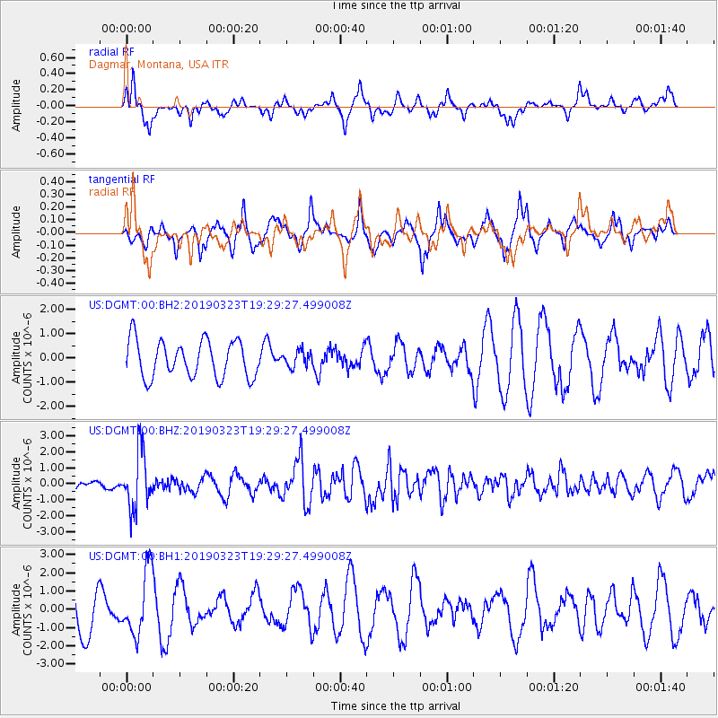
Signal To Noise
| Channel | StoN | STA | LTA |
| US:DGMT:00:BHZ:20190323T19:29:27.499008Z | 4.003631 | 1.7854459E-6 | 4.4595666E-7 |
| US:DGMT:00:BH1:20190323T19:29:27.499008Z | 1.6139088 | 1.7788757E-6 | 1.1022158E-6 |
| US:DGMT:00:BH2:20190323T19:29:27.499008Z | 0.4320968 | 3.260844E-7 | 7.546559E-7 |
| Arrivals |
| Ps | |
| PpPs | |
| PsPs/PpSs | |


