You are here: Home > Network List > TA - USArray Transportable Network (new EarthScope stations) Stations List
> Station B29A Wagenman Farm, Cando, ND, USA > Earthquake Result Viewer
B29A Wagenman Farm, Cando, ND, USA - Earthquake Result Viewer
| Earthquake location: |
Near Coast Of Central Chile |
| Earthquake latitude/longitude: |
-37.0/-73.4 |
| Earthquake time(UTC): |
2010/09/09 (252) 07:28:01 GMT |
| Earthquake Depth: |
16 km |
| Earthquake Magnitude: |
5.8 MB, 6.0 MS, 6.2 MW, 6.2 MW |
| Earthquake Catalog/Contributor: |
WHDF/NEIC |
|
| Network: |
TA USArray Transportable Network (new EarthScope stations) |
| Station: |
B29A Wagenman Farm, Cando, ND, USA |
| Lat/Lon: |
48.46 N/99.35 W |
| Elevation: |
460 m |
|
| Distance: |
88.2 deg |
| Az: |
343.064 deg |
| Baz: |
159.499 deg |
| Ray Param: |
0.04275078 |
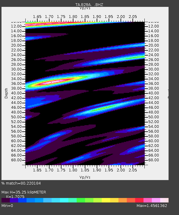
| Estimated Moho Depth: |
35.25 km |
| Estimated Crust Vp/Vs: |
1.71 |
| Assumed Crust Vp: |
6.53 km/s |
| Estimated Crust Vs: |
3.825 km/s |
| Estimated Crust Poisson's Ratio: |
0.24 |
|
| Radial Match: |
80.220184 % |
| Radial Bump: |
371 |
| Transverse Match: |
73.45752 % |
| Transverse Bump: |
400 |
| SOD ConfigId: |
319893 |
| Insert Time: |
2011-01-13 09:46:50.220 +0000 |
| GWidth: |
2.5 |
| Max Bumps: |
400 |
| Tol: |
0.001 |
|

Signal To Noise
| Channel | StoN | STA | LTA |
| TA:B29A: :BHZ:20100909T07:40:20.375029Z | 3.4966934 | 3.4084016E-7 | 9.747499E-8 |
| TA:B29A: :BHN:20100909T07:40:20.375029Z | 0.93544567 | 2.4876465E-7 | 2.659317E-7 |
| TA:B29A: :BHE:20100909T07:40:20.375029Z | 1.4208174 | 3.023641E-7 | 2.1280997E-7 |
| Arrivals |
| Ps | 3.9 SECOND |
| PpPs | 14 SECOND |
| PsPs/PpSs | 18 SECOND |


