You are here: Home > Network List > TA - USArray Transportable Network (new EarthScope stations) Stations List
> Station L30A Spencer Herefords Ranch, Brewster, NE, USA > Earthquake Result Viewer
L30A Spencer Herefords Ranch, Brewster, NE, USA - Earthquake Result Viewer
| Earthquake location: |
Near Coast Of Central Chile |
| Earthquake latitude/longitude: |
-37.0/-73.4 |
| Earthquake time(UTC): |
2010/09/09 (252) 07:28:01 GMT |
| Earthquake Depth: |
16 km |
| Earthquake Magnitude: |
5.8 MB, 6.0 MS, 6.2 MW, 6.2 MW |
| Earthquake Catalog/Contributor: |
WHDF/NEIC |
|
| Network: |
TA USArray Transportable Network (new EarthScope stations) |
| Station: |
L30A Spencer Herefords Ranch, Brewster, NE, USA |
| Lat/Lon: |
41.95 N/99.72 W |
| Elevation: |
782 m |
|
| Distance: |
82.2 deg |
| Az: |
340.507 deg |
| Baz: |
159.025 deg |
| Ray Param: |
0.047041375 |
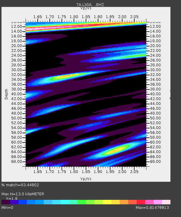
| Estimated Moho Depth: |
13.0 km |
| Estimated Crust Vp/Vs: |
1.60 |
| Assumed Crust Vp: |
6.53 km/s |
| Estimated Crust Vs: |
4.082 km/s |
| Estimated Crust Poisson's Ratio: |
0.18 |
|
| Radial Match: |
83.44902 % |
| Radial Bump: |
359 |
| Transverse Match: |
77.986885 % |
| Transverse Bump: |
400 |
| SOD ConfigId: |
319893 |
| Insert Time: |
2011-01-13 09:47:02.221 +0000 |
| GWidth: |
2.5 |
| Max Bumps: |
400 |
| Tol: |
0.001 |
|
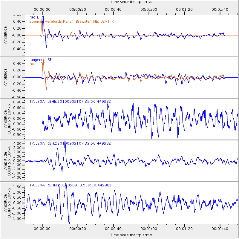
Signal To Noise
| Channel | StoN | STA | LTA |
| TA:L30A: :BHZ:20100909T07:39:50.44998Z | 3.740455 | 3.437529E-7 | 9.190136E-8 |
| TA:L30A: :BHN:20100909T07:39:50.44998Z | 0.818305 | 3.1555453E-7 | 3.8561967E-7 |
| TA:L30A: :BHE:20100909T07:39:50.44998Z | 1.1485028 | 3.058271E-7 | 2.6628328E-7 |
| Arrivals |
| Ps | 1.2 SECOND |
| PpPs | 5.0 SECOND |
| PsPs/PpSs | 6.3 SECOND |


