You are here: Home > Network List > US - United States National Seismic Network Stations List
> Station HAWA Hanford, Washington, USA > Earthquake Result Viewer
HAWA Hanford, Washington, USA - Earthquake Result Viewer
*The percent match for this event was below the threshold and hence no stack was calculated.
| Earthquake location: |
Guatemala |
| Earthquake latitude/longitude: |
14.1/-90.5 |
| Earthquake time(UTC): |
2024/01/27 (027) 05:52:49 GMT |
| Earthquake Depth: |
108 km |
| Earthquake Magnitude: |
6.1 Mww |
| Earthquake Catalog/Contributor: |
NEIC PDE/us |
|
| Network: |
US United States National Seismic Network |
| Station: |
HAWA Hanford, Washington, USA |
| Lat/Lon: |
46.39 N/119.53 W |
| Elevation: |
364 m |
|
| Distance: |
40.3 deg |
| Az: |
328.768 deg |
| Baz: |
133.38 deg |
| Ray Param: |
$rayparam |
*The percent match for this event was below the threshold and hence was not used in the summary stack. |
|
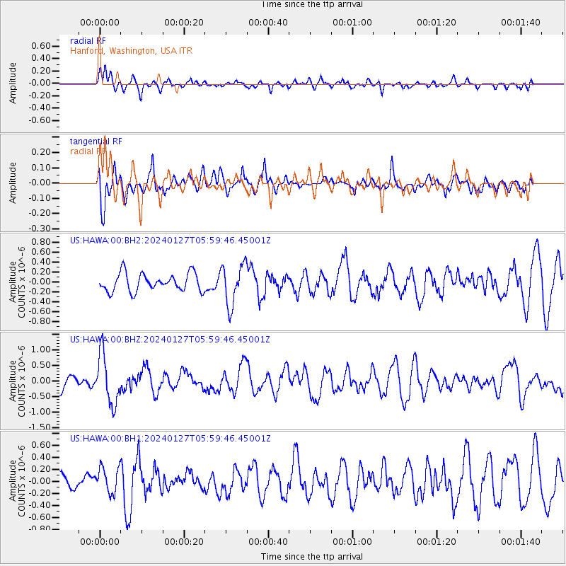
| Radial Match: |
65.69509 % |
| Radial Bump: |
400 |
| Transverse Match: |
63.50129 % |
| Transverse Bump: |
400 |
| SOD ConfigId: |
33437571 |
| Insert Time: |
2024-02-10 06:17:27.104 +0000 |
| GWidth: |
2.5 |
| Max Bumps: |
400 |
| Tol: |
0.001 |
|
Signal To Noise
| Channel | StoN | STA | LTA |
| US:HAWA:00:BHZ:20240127T05:59:46.45001Z | 3.693715 | 8.1132254E-7 | 2.1964946E-7 |
| US:HAWA:00:BH1:20240127T05:59:46.45001Z | 1.215657 | 2.1563882E-7 | 1.7738459E-7 |
| US:HAWA:00:BH2:20240127T05:59:46.45001Z | 2.3457453 | 4.1985953E-7 | 1.7898769E-7 |
| Arrivals |
| Ps | |
| PpPs | |
| PsPs/PpSs | |


