You are here: Home > Network List > TA - USArray Transportable Network (new EarthScope stations) Stations List
> Station S32A Newby Ranch, Pratt, KS, USA > Earthquake Result Viewer
S32A Newby Ranch, Pratt, KS, USA - Earthquake Result Viewer
| Earthquake location: |
Near Coast Of Central Chile |
| Earthquake latitude/longitude: |
-37.0/-73.4 |
| Earthquake time(UTC): |
2010/09/09 (252) 07:28:01 GMT |
| Earthquake Depth: |
16 km |
| Earthquake Magnitude: |
5.8 MB, 6.0 MS, 6.2 MW, 6.2 MW |
| Earthquake Catalog/Contributor: |
WHDF/NEIC |
|
| Network: |
TA USArray Transportable Network (new EarthScope stations) |
| Station: |
S32A Newby Ranch, Pratt, KS, USA |
| Lat/Lon: |
37.70 N/98.94 W |
| Elevation: |
558 m |
|
| Distance: |
78.0 deg |
| Az: |
339.549 deg |
| Baz: |
159.36 deg |
| Ray Param: |
0.049915865 |
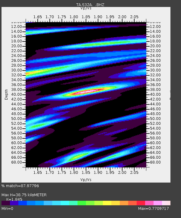
| Estimated Moho Depth: |
38.75 km |
| Estimated Crust Vp/Vs: |
1.85 |
| Assumed Crust Vp: |
6.426 km/s |
| Estimated Crust Vs: |
3.483 km/s |
| Estimated Crust Poisson's Ratio: |
0.29 |
|
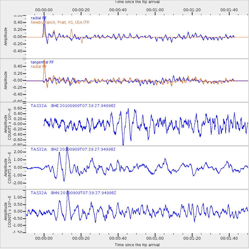
| Radial Match: |
87.97796 % |
| Radial Bump: |
400 |
| Transverse Match: |
69.86734 % |
| Transverse Bump: |
400 |
| SOD ConfigId: |
319893 |
| Insert Time: |
2011-01-13 09:48:20.320 +0000 |
| GWidth: |
2.5 |
| Max Bumps: |
400 |
| Tol: |
0.001 |
|
Signal To Noise
| Channel | StoN | STA | LTA |
| TA:S32A: :BHZ:20100909T07:39:27.94998Z | 3.2457829 | 2.2819233E-7 | 7.030425E-8 |
| TA:S32A: :BHN:20100909T07:39:27.94998Z | 1.1568617 | 1.3011322E-7 | 1.1247086E-7 |
| TA:S32A: :BHE:20100909T07:39:27.94998Z | 0.8457713 | 1.0800236E-7 | 1.2769688E-7 |
| Arrivals |
| Ps | 5.2 SECOND |
| PpPs | 17 SECOND |
| PsPs/PpSs | 22 SECOND |


