You are here: Home > Network List > TA - USArray Transportable Network (new EarthScope stations) Stations List
> Station T33A Patterson Ranch, Waldron, KS, USA > Earthquake Result Viewer
T33A Patterson Ranch, Waldron, KS, USA - Earthquake Result Viewer

| Earthquake location: |
Near Coast Of Central Chile |
| Earthquake latitude/longitude: |
-37.0/-73.4 |
| Earthquake time(UTC): |
2010/09/09 (252) 07:28:01 GMT |
| Earthquake Depth: |
16 km |
| Earthquake Magnitude: |
5.8 MB, 6.0 MS, 6.2 MW, 6.2 MW |
| Earthquake Catalog/Contributor: |
WHDF/NEIC |
|
| Network: |
TA USArray Transportable Network (new EarthScope stations) |
| Station: |
T33A Patterson Ranch, Waldron, KS, USA |
| Lat/Lon: |
37.08 N/98.24 W |
| Elevation: |
394 m |
|
| Distance: |
77.2 deg |
| Az: |
339.858 deg |
| Baz: |
159.845 deg |
| Ray Param: |
0.050439518 |
| Estimated Moho Depth: |
42.75 km |
| Estimated Crust Vp/Vs: |
1.84 |
| Assumed Crust Vp: |
6.426 km/s |
| Estimated Crust Vs: |
3.492 km/s |
| Estimated Crust Poisson's Ratio: |
0.29 |
|
| Radial Match: |
93.07366 % |
| Radial Bump: |
308 |
| Transverse Match: |
76.38428 % |
| Transverse Bump: |
400 |
| SOD ConfigId: |
319893 |
| Insert Time: |
2011-01-13 09:48:25.021 +0000 |
| GWidth: |
2.5 |
| Max Bumps: |
400 |
| Tol: |
0.001 |
|
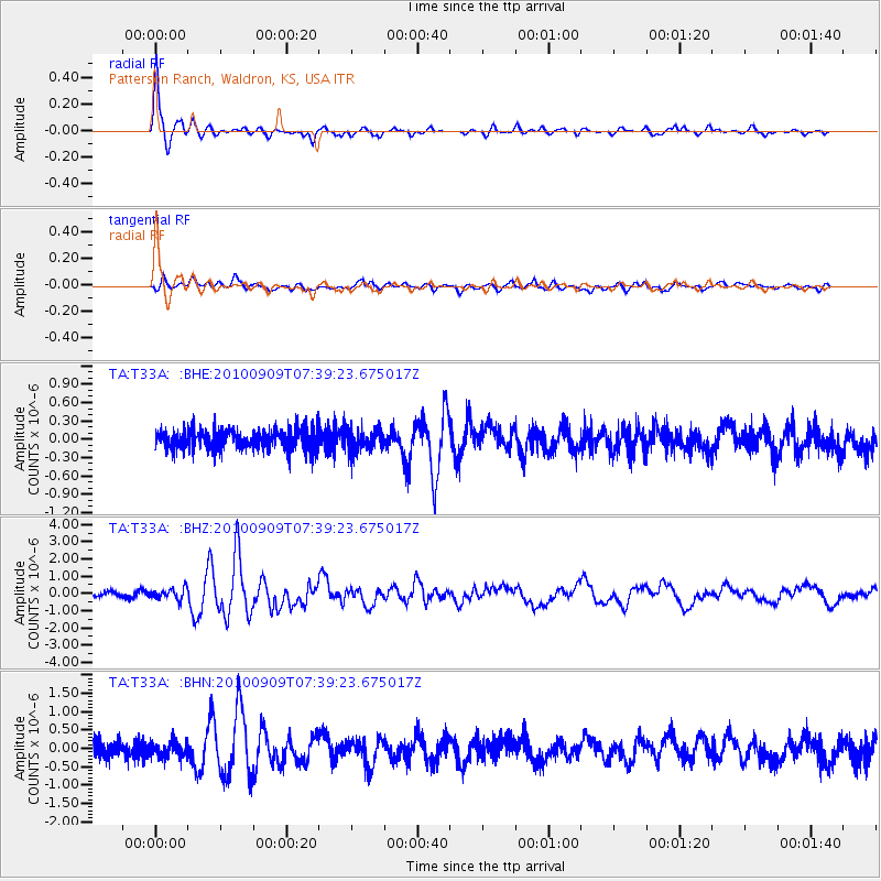
Signal To Noise
| Channel | StoN | STA | LTA |
| TA:T33A: :BHZ:20100909T07:39:23.675017Z | 2.5651467 | 3.2439013E-7 | 1.2646066E-7 |
| TA:T33A: :BHN:20100909T07:39:23.675017Z | 1.0604725 | 2.1021208E-7 | 1.9822491E-7 |
| TA:T33A: :BHE:20100909T07:39:23.675017Z | 1.0991968 | 1.8288485E-7 | 1.6638043E-7 |
| Arrivals |
| Ps | 5.8 SECOND |
| PpPs | 18 SECOND |
| PsPs/PpSs | 24 SECOND |


